
Soil/Landform Unit - Mount William Creek2
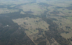 Mount William Creek with remnant vegetation aligning floodplains and significant creek flow |
0.45% of CMA region This unit consists of a few small discreet depositional entities that form the upper part of the Mt William Creek alluvial sequence that divides the Grampians Ranges (to the west) from the Dissected Uplands to the east. As a unit within the defined terraces and floodplains subdivision (2.1.7) of the Dissected Western Uplands, the extensive alluvial Quaternary sediments abut colluvial sediments (Grampians Plains) to the west, as well as older sedimentary and volcanic rock units (e.g. Mt Dryden) to the east. Dominated by alluvial plains, drainage depressions, alluvial flats and bordering dunes also occur within the plains. Drainage is mainly dendritic and extensive away from the main drainage lines. Soil types are predominantly yellow and brown gradational (Dermosols) and texture contrast soils (Chromosols) with yellow, brown and grey sodic texture contrast soils (Sodosols) occurring on lower slopes and minor depressions. Seasonal inundation is more likely due to runoff from these steeper surrounding slopes and the more extensive, flatter plains. Grazing (sheep and cattle) is the major enterprise. Common remnant vegetation communities recorded include woodlands (e.g. Lateritic, Plains Grassy, Heathy, Herb-rich) and Sand Heathland. | 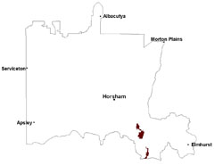 |
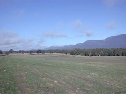 Looking south along Mount William Creek | 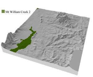 |
 | 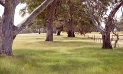 Red gum on alluvial plains |
Component | 1 | 2 | 3 | 4 | 5 |
Proportion of soil-landform unit | 50% | 15% | 15% | 15% | 5% |
| CLIMATE Rainfall (mm) | Annual: 720 | ||||
| Temperature (oC) | Minimum 8, Maximum 20 | ||||
| Precipitation less than potential evapotranspiration | October–March | ||||
| GEOLOGY Age and lithology | |||||
| Geomorphology | |||||
| LANDUSE | Uncleared areas: water supply; nature conservation Cleared areas: sheep and beef cattle grazing; dryland cropping; water supply | ||||
| TOPOGRAPHY Landscape | Alluvial plain | ||||
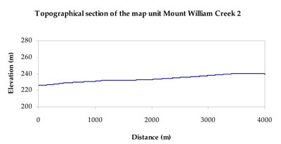
| Elevation range (m) | 168–370 | ||||
| Local relief (m) | 2 | ||||
| Drainage pattern | Dendritic | ||||
| Drainage density (km/km2) | 1.3 | ||||
| Landform | Alluvial plains | ||||
| Landform element | Plain | Drainage depression | Alluvial flat | Drainage line | Dune |
| Slope and range (%) | 1 (0-3) | 1 (0-1) | 0 (0-1) | 1 (0-1) | 2 (0-5) |
| Slope shape | Straight | Concave | Straight | Concave | Convex |
| NATIVE VEGETATION Ecological Vegetation Class | Plains Grassy Woodland (38.6%), Plains Woodland/Plains SedgyWoodland/Damp Sands Herb-rich Woodland Mosaic (8.1%), Heathy Woodland (7.5%), Damp Sands Herb-rich Woodland (6.0%), Other (34.8%) | ||||
| SOIL Parent material | Fluvial gravel, sand and silt | Alluvial gravel, sand and silt | Alluvial gravel, sand and silt | Alluvial gravel, sand and silt | Aeolian dune sand |
| Description (Corangamite Soil Group) | Yellow and brown gradational and texture contrast soils (11) | Sodic brown, yellow and grey texture contrast soils (12) | Sandy gradational soils (14) | ||
| Soil type sites | GRAMP335 | ||||
| Surface texture | Loamy sand | Loam, fine sandy (heavy) | Loam, fine sandy to loamy sand | Loam, fine sandy to loamy sand | Sandy loam |
| Permeability | Moderate to high | Slow | Slow | Very slow | High |
| Depth (m) | > 2 | > 2 | > 2 | > 2 | > 2 |
| LAND CHARACTERISTICS, POTENTIAL AND LIMITATIONS Critical land features, processes, forms | Lighter surface susceptible to sheet and rill erosion and compaction. Subsoil susceptible to rill and gully erosion where sodic and deeper. Lighter variants are well drained. | Lighter surface susceptible to sheet and rill erosion and compaction. Subject to periodic inundation and waterlogging, especially during flood events. Lighter soil variants are well drained within the depressions. Upper soil susceptible to acidification. | Lighter surface susceptible to sheet and rill erosion and compaction. Subject to periodic inundation and waterlogging, especially during flood events. Lighter soil variants are well drained within the depressions. Upper soil susceptible to acidification. | Lighter surface susceptible to sheet and rill erosion and compaction. Subject to periodic inundation and waterlogging, especially during flood events. | Light sandy soils generally rapidly drained. Weakly coherent surfaces with little organic matter are susceptible to sheet and wind erosion where exposed. Acidic soils with low inherent fertility. |
© State of Victoria (Agriculture Victoria) 1996 - .

This work, Victorian Resources Online, is licensed under a Creative Commons Attribution 4.0 licence. You are free to re-use the work under that licence, on the condition that you credit the State of Victoria (Agriculture Victoria) as author, indicate if changes were made and comply with the other licence terms.
The licence does not apply to ‘branding’ or some ‘images or photographs’ that may be owned by third parties. We ask you to seek prior approval to use images using the VRO feedback form. Access to higher quality images can also be provided on request.
This page was last updated on .