
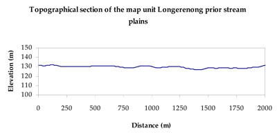
Soil/Landform Unit - Longerenong prior stream plains
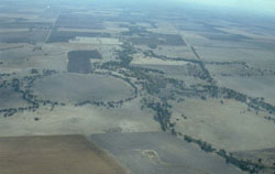 Darlot Swamp and Two Mile Creek north of Longerenong |
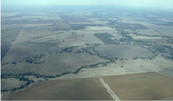
0.48% of CMA region Prior stream floodplains south-west of Murtoa comprise this relatively flat to gently undulating landscape. Occurring within the plains with leveed channels of the older alluvial plains (4.2.1), soils can be quite variable on landform components including rise and side slopes, level plains and alluvial flats along with drainage lines. Self-mulching to massive cracking clays (Vertosols), sodic red, brown, grey and yellow texture contrast soils (Sodosols) along with sandy equivalents are predominant soil types and reflect geomorphology and today’s microtopography of these floodplains. Woodlands such as Shallow Sands Woodland, Plains Woodland, Riverine Chenopod Woodland, Riverina Woodland, Low Rises Woodland and Floodplain Riparian Woodland dominate remnant vegetation. Land use is mixed between irrigated cropping and dryland cereal cropping with sheep grazing a minor enterprise. Occassionally these plains will flood in significantly wet seasons. | 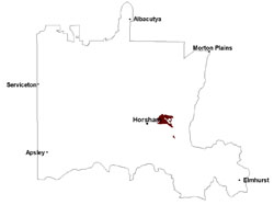 |
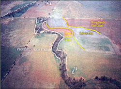 Prior stream floodplain landscape near Murtoa | 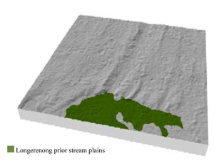 |
 |  Darlot Swamp |
Component | 1 | 2 | 3 | 4 |
Proportion of soil-landform unit | 10% | 60% | 20% | 10% |
| CLIMATE Rainfall (mm) | Annual: 460 | |||
| Temperature (oC) | Minimum 8, Maximum 21 | |||
| Precipitation less than potential evapotranspiration | September–April | |||
| GEOLOGY Age and lithology | Quaternary fluvial gravel, sand and silt; Quaternary fluvial silt, sand and minor gravel (Shepparton Formation) | |||
| Geomorphology | ||||
| LANDUSE | Uncleared areas: nature conservation Cleared areas: dryland cropping; sheep grazing; pasture and cereal horticulture | |||
| TOPOGRAPHY Landscape | Floodplain | |||
| Elevation range (m) | 126-155 | |||
| Local relief (m) | 1–2 | |||
| Drainage pattern | Deranged–Dendritic | |||
| Drainage density (km/km2) | 1.2 | |||
| Landform | Gentle rise slopes and plains | Prior stream floodplains | ||
| Landform element | Rise and side slope | Level plain | Alluvial flat | Drainage line |
| Slope and range (%) | 2 (0-7) | 1 (0-3) | 0 (0-1) | 0 (0-1) |
| Slope shape | Convex | Straight | Straight | Concave |
| NATIVE VEGETATION Ecological Vegetation Class | Riverine Chenopod Woodland (31.5%), Shallow Sands Woodland (16.9%), Low Rises Woodland (15.3%), Plains Woodland (11.1%), Other (25.1%) | |||
| SOIL Parent material | Fluvial gravel, sand and silt | Fluvial gravel, sand and silt | Fluvial gravel, sand and silt | Fluvial gravel, sand and silt |
| Description (Corangamite Soil Group) | Sodic red texture contrast soils (25) | Cracking clay soils (23) | Cracking clay soils (23) | |
| Soil type sites | ||||
| Surface texture | Fine sandy loam | Sandy clay loam - light clay | Light clay | Light clay |
| Permeability | Slow | Slow | Very slow | Very slow |
| Depth (m) | > 2 | > 2 | > 2 | > 2 |
| LAND CHARACTERISTICS, POTENTIAL AND LIMITATIONS Critical land features, processes, forms | Hardsetting soil slightly susceptible to sheet and rill erosion. Soils are prone to compaction at critical moisture contents. Subsoil susceptible to gully erosion when exposed due to dispersive (sodic) nature. Slight susceptibility to acidification of surface soil. | Plains susceptible to inundation and waterlogging during flood events. Surface soils are generally not friable and susceptible to compaction (less structure). | Flat areas susceptible to inundation and waterlogging, especially from flood events, but localised can be variable due to micro relief (gilgai). Surface soils are generally not friable and are susceptible to compaction (less structure). | Drainage lines are seasonally inundated and waterlogged. Surface soils generally not friable and are susceptible to compaction (less structure). |
© State of Victoria (Agriculture Victoria) 1996 - .

This work, Victorian Resources Online, is licensed under a Creative Commons Attribution 4.0 licence. You are free to re-use the work under that licence, on the condition that you credit the State of Victoria (Agriculture Victoria) as author, indicate if changes were made and comply with the other licence terms.
The licence does not apply to ‘branding’ or some ‘images or photographs’ that may be owned by third parties. We ask you to seek prior approval to use images using the VRO feedback form. Access to higher quality images can also be provided on request.
This page was last updated on .