
WIA16
|
| WIA16 | 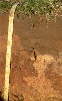 Calcic, Mesonatric, Red Sodosol | |
|
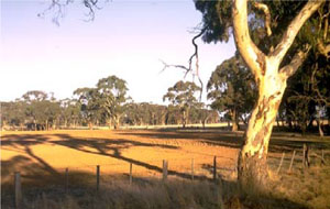
Location | Corkers Creek Rd, Longerenong, Western Victoria | |||
|
Landform | Floodplain (prior stream). | |||
|
Geology | Quaternary Shepparton Formation: fluvial silt, sand and minor gravel. | |||
|
Element | Levee | |||
|
Slope | 0–1% | |||
Horizon | Depth (cm) | Description | ||
A1 | 0–5 | Dark yellowish brown (10YR4/4); light fine sandy loam; hard setting surface condition; weak coarse granular structure; very strong consistence dry; pH 5.9; sharp and irregular boundary to: | ||
A2e | 5–20 | Dark brown (7.5YR4/4) conspicuously bleached (7.5YR7/3); light fine sandy loam; weak coarse granular structure; weak consistence dry; pH 6.0; sharp boundary to: | ||
A3e | 20–25 | Dark brown (7.5YR4/4) conspicuously bleached (7.5YR7/3); fine sandy loam; massive (structureless); very strong consistence dry; pH 8.5; sharp and wavy change to: | ||
B21 | 25–45 | Yellowish red (5YR4/6); medium clay; weak very coarse prismatic structure; pH 9.0; gradual boundary to: | ||
B22 | 45–70 | Strong brown (7.5YR5/6); light clay; weak coarse prismatic structure; pH 9.5; gradual boundary to: | ||
B23k | 70–95 | Strong brown (7.5YR5/6); medium clay; weak coarse prismatic structure; few (2-10%) soft carbonates; pH 9.7; sharp and wavy boundary to: | ||
B32k | 95–130 | Brown (10YR5/3) with distinct yellowish red (5YR4/6) mottles; sandy clay; weak coarse subangular blocky structure; few (210%) soft carbonates; pH 9.7. | ||
| Management Considerations | ||||
| ||||
Site WIA16 | Sample depth cm | pH | EC dS/m | NaCl % | Ex Ca cmol-/kg | Ex Mg cmol-/kg | Ex K cmol-/kg | Ex Na cmol-/kg | Ex Al mg/kg | Ex acidity cmol-/kg | FC -30okPa | PWP -1500okPa | KS % | FS % | Z % | C % | |
Horizon | H2O | CaCl2 | |||||||||||||||
A1 | 0–5 | 5.9 | NA | 0.06 | 0.01 | 1.4 | 0.4 | 0.3 | 2.7 | NA | 2.7 | NA | 2.2 | 13 | 71 | 7 | 9 |
A2e | 5–20 | 6 | 5.2 | 0.02 | 0.01 | 2.2 | 0.7 | 0.2 | 0.1 | NA | 0.7 | 11.7 | 1.4 | 12 | 71 | 11 | 6 |
A3e | 20–25 | 8.5 | NA | 0.09 | 0.02 | 1.3 | 2.3 | 0.3 | 1.2 | NA | 0.5 | NA | 5.4 | 9 | 62 | 11 | 16 |
B21 | 25–45 | 9 | NA | 0.17 | 0.04 | 6.4 | 8.0 | 1.0 | 4.0 | NA | 1.0 | NA | 15.1 | 4 | 46 | 9 | 40 |
B22 | 45–70 | 9.5 | NA | 0.67 | 0.1 | 2.6 | 7.6 | 1.0 | 4.7 | NA | NA | 30.5 | 13.7 | 2 | 45 | 18 | 33 |
B23k | 70–95 | 9.7 | NA | 0.85 | 0.13 | 2.6 | 7.3 | 0.9 | 4.7 | NA | NA | NA | 12.8 | 11 | 27 | 28 | 30 |
B31k | 95–130 | 9.7 | NA | 0.72 | 0.11 | 2.4 | 8.6 | 1.0 | 5.6 | NA | NA | NA | 13.1 | 23 | 42 | 5 | 29 |
B32 | 130–165 | 9.6 | NA | 1.08 | 0.16 | NA | NA | NA | NA | NA | NA | NA | 18.9 | 16 | 31 | 5 | 41 |
B33 | 165–205 | 9.6 | NA | 1.08 | 0.16 | NA | NA | NA | NA | NA | NA | NA | 19.5 | 14 | 29 | 7 | 44 |
© State of Victoria (Agriculture Victoria) 1996 - .

This work, Victorian Resources Online, is licensed under a Creative Commons Attribution 4.0 licence. You are free to re-use the work under that licence, on the condition that you credit the State of Victoria (Agriculture Victoria) as author, indicate if changes were made and comply with the other licence terms.
The licence does not apply to ‘branding’ or some ‘images or photographs’ that may be owned by third parties. We ask you to seek prior approval to use images using the VRO feedback form. Access to higher quality images can also be provided on request.
This page was last updated on .