
Soil/Landform Unit - Hindmarsh-Albacutya lunette
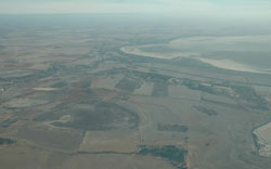 Wimmera River entrance to Lake Hindmarsh north of Jeparit |
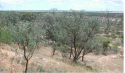
0.56% of CMA region Lunettes in the north of the catchment are pronounced features of subtle to undulating landscapes of the North-western Dunefields and Plains. Lake Albacutya, Lake Hindmarsh and numerous smaller swamps/lakes have provided sources of materials for these eastern bordering lunettes. The lunettes can be quite extensive owing to reworking of aeolian sediments and a series of arid phases that saw lake deposits deposited on eastern lake margins. Soils of these lunettes can be quite variable including sandy profiles, red sodic texture contrast soils (Sodosols), heavier clay soils (Vertosols) along with calcareous gradational soils (Calcarosols). As aeolian deposits, these soils remain prone to wind erosion where exposed. Land use is mainly cereal cropping with some areas still under native vegetation where likely productivity was considered low during settlement. Ecological vegetation communities recorded include; Sandstone Ridge Shrubland, Red Swale Mallee and Parilla Mallee which are found on sandstone ridges and rises. Low Rises Woodland, Lowan Sands Mallee, Heathy Mallee, Dunefield Heathland, Riverine Chenopod Woodland, Plains Woodland and Plains Savannah vegetation have also been recorded on lunettes and swales. | 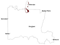 |
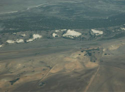 Blow outs within the lunette of Lake Hindmarsh | 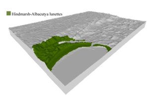 |
 |  Lunette and lake plain of Lake Hindmarsh |
Component | 1 | 2 | 3 | 4 | 5 |
Proportion of soil-landform unit | 25% | 5% | 10% | 50% | 10% |
| CLIMATE Rainfall (mm) | Annual: 365 | ||||
| Temperature (oC) | Minimum 9, Maximum 22 | ||||
| Precipitation less than potential evapotranspiration | September–April | ||||
| GEOLOGY Age and lithology | Quaternary paludal silt and clay; Neogene marine sand and silt (Parilla Sand); Quaternary aeolian dune sand (Lowan Sand) | ||||
| Geomorphology | |||||
| LANDUSE | Uncleared areas: Water supply; nature conservation; recreational activities Cleared areas: Dryland cropping; sheep grazing; water supply | ||||
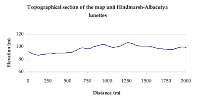
| TOPOGRAPHY Landscape | Lunette and plains | ||||
| Elevation range (m) | 71–128 | ||||
| Local relief (m) | 10 | ||||
| Drainage pattern | Dendritic–deranged | ||||
| Drainage density (km/km2) | 0.3 | ||||
| Landform | Shoreline plains | Lunette sequences | |||
| Landform element | Floodplain/playa | Dune crest (reworked lunette sediments) | Lunette | Dune slope (reworked lunette sediments) | Swale |
| Slope and range (%) | 1 (0-5) | 14 (10-20) | 10 (3-32) | 7 (3-15) | 4 (2-9) |
| Slope shape | Concave | Convex | Convex | Linear | Concave |
| NATIVE VEGETATION Ecological Vegetation Class | Parilla Mallee (15.5%), Low Rises Woodland (15.1%), Sandstone Ridge Shrubland (13.8%), Intermittent Swampy Woodland (12.6%), Other (42.3%) | ||||
| SOIL Parent material | Paludal silt and clay, marine sand and silt | Aeolian sand | Aeolian sand | Aeolian sand | Paludal silt and clay |
| Description (Corangamite Soil Group) | Cracking and self-mulching clay soils (24) | Sodic red texture contrast soils (25) | Sodic red texture contrast soils (25) | Cracking clay soils (23) | |
| Soil type sites | |||||
| Surface texture | Medium clay | Fine sandy loam | Sandy clay loam to light clay | Fine sandy loam | Light clay |
| Permeability | Slow | Slow | Very slow | Slow | Very slow |
| Depth (m) | > 3 | > 2 | > 2 | > 2 | > 2 |
| LAND CHARACTERISTICS, POTENTIAL AND LIMITATIONS Critical land features, processes, forms | Flat areas, susceptible to inundation and waterlogging. Surface soils friable and only slightly susceptible to wind erosion, however are vulnerable where ground coverage is poor. Soils may be susceptible to compaction at critical moisture contents. | Soil slightly susceptible to sheet and rill erosion along with wind erosion. Soils are prone to compaction at critical moisture contents. Subsoil susceptible to gully erosion when exposed due to dispersive (sodic) nature. | Surface soils generally not friable and are susceptible to compaction (less structure). Wind erosion occurs where ground coverage is insufficient to protect aeolian material. | Hardsetting soil susceptible to sheet and wind erosion. Soils are prone to compaction at critical moisture contents. Subsoil susceptible to gully erosion when exposed due to dispersive (sodic) nature. | Flat areas susceptible to inundation and waterlogging, but can be variable locally due to micro relief (gilgai). Surface soils generally not friable that are susceptible to compaction (less structure). |
© State of Victoria (Agriculture Victoria) 1996 - .

This work, Victorian Resources Online, is licensed under a Creative Commons Attribution 4.0 licence. You are free to re-use the work under that licence, on the condition that you credit the State of Victoria (Agriculture Victoria) as author, indicate if changes were made and comply with the other licence terms.
The licence does not apply to ‘branding’ or some ‘images or photographs’ that may be owned by third parties. We ask you to seek prior approval to use images using the VRO feedback form. Access to higher quality images can also be provided on request.
This page was last updated on .