
Soil/Landform Unit - Grampians outwash slope
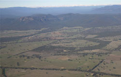 Outwash slopes of the Grampians Ranges, looking eastwards over the MacKenzie River towards Wartook |
0.55% of CMA region Surrounding the Grampians Ranges are hillslopes that represent significant colluvial and alluvial deposits of Grampians sand and silt. Outwash slopes are far more extensive in the north of the Grampians Ranges than the south where local relief is varied between 15 and 45 metres. A significant source of high quality groundwater, these sands comprise acidic, grey texture contrast soils with deep sandy surfaces (Kurosols) and sandy soils with pans (Podosols). The light sandy surface soils are subject to mass movement (creep and sheet flow) on steep slopes where exposed, yet remain well to rapidly drained. Wind erosion may also be extensive where soil surfaces are exposed. There are many different vegetation types including woodlands, forest and shrubland. Some of the more prevalent vegetation communities include Valley Grassy Forest and Shrubby Foothill Forest in sheltered areas of the landscape, Heathy Dry Forest and Grassy Dry Forest in more exposed areas, and other communities such as Shallow Sands Woodland, Lateritic Woodland, Damp Sands Herb-rich Woodland, and Rocky Outcrop Shrubland. | 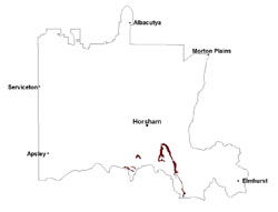 |
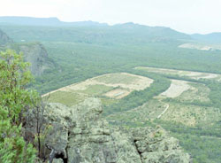 Cleared alluvial outwsh slopes used in an olive plantation | 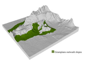 |
 | 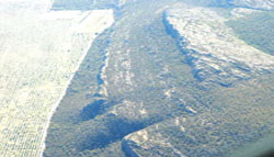 Mount Difficult sandstone range with outwash slopes on the western margin |
Component | 1 | 2 | 3 |
Proportion of soil-landform unit | 65% | 15% | 20% |
| CLIMATE Rainfall (mm) | Annual: 815 | ||
| Temperature (oC) | Minimum 7, Maximum 19 | ||
| Precipitation less than potential evapotranspiration | October–March | ||
| GEOLOGY Age and lithology | Quaternary colluvium, gravel, sand and silt; Silurian marine and non-marine sandstone, siltstone and minor conglomerate (Grampians Group); Quaternary alluvium, gravel, sand and silt | ||
| Geomorphology | |||
| LANDUSE | Uncleared areas: water supply; nature conservation Cleared areas: sheep grazing; viticulture; olive plantations; lavender; stone fruit; residential development; water supply | ||
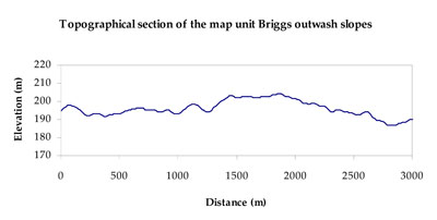
| TOPOGRAPHY Landscape | Outwash hillslopes | ||
| Elevation range (m) | 165–634 | ||
| Local relief (m) | 15–45 | ||
| Drainage pattern | Parallel | ||
| Drainage density (km/km2) | 1.1 | ||
| Landform | Undulating outwash plains and rises | ||
| Landform element | Undulating rise | Drainage line | Hillslope (scree) |
| Slope and range (%) | 5 (1-15) | 5 (3-10) | 12 (5-30) |
| Slope shape | Convex | Concave | Concave |
| NATIVE VEGETATION Ecological Vegetation Class | Heathy Woodland (13.2%), Sand Heathland (10.3%), Damp Sands Herb-rich Woodland (9.5%), Rocky Outcrop Herbland (8.0%), Shallow Sands Woodland (6.8%), Other (47.1%) | ||
| SOIL Parent material | Sandstone, siltstone and minor conglomerates | Alluvial gravel, sand and silt | Colluvial gravel, sand, silt and sandstone |
| Description (Corangamite Soil Group) | Acidic, grey texture contrast soils (sandy surfaces) (16) | Sandy soils with pans (15) | Sandy soils with pans (15) |
| Soil type sites | |||
| Surface texture | Loamy sand | Loamy sand | Loamy sand |
| Permeability | High | High | High |
| Depth (m) | > 2 | > 2 | > 2 |
| LAND CHARACTERISTICS, POTENTIAL AND LIMITATIONS Critical land features, processes, forms | Light sandy surface soils subject to mass movement (creep and sheet flow) on steep slopes, generally well to rapidly drained. Weakly coherent surfaces with little organic matter are susceptible to sheet and wind erosion where exposed. Acidic sandy soils with a low inherent soil fertility. | Light sandy soils generally well drained to hardpan or rock. Weakly coherent surfaces with little organic matter are susceptible to sheet and wind erosion where exposed. Acidic soils with a low inherent soil fertility. Groundwater springs from Grampians colluvium are often associated with depressions. | Light sandy soils subject to mass movement (creep and sheet flow) on steep slopes, generally rapidly drained to hardpan or rock. Weakly coherent surfaces with little organic matter are susceptible to sheet and wind erosion where exposed. Acidic soils with a low inherent soil fertility. |
© State of Victoria (Agriculture Victoria) 1996 - .

This work, Victorian Resources Online, is licensed under a Creative Commons Attribution 4.0 licence. You are free to re-use the work under that licence, on the condition that you credit the State of Victoria (Agriculture Victoria) as author, indicate if changes were made and comply with the other licence terms.
The licence does not apply to ‘branding’ or some ‘images or photographs’ that may be owned by third parties. We ask you to seek prior approval to use images using the VRO feedback form. Access to higher quality images can also be provided on request.
This page was last updated on .