
ALRA66
|
| ALRA66 | 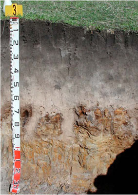 Parapanic, Humosesquic, Aeric Podosol | |
|
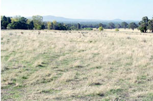
Location | Long Gully Road, Pomonal | |||
|
Landform | Scarp-footslope | |||
|
Geology | Grampians colluvium | |||
|
Element | Hillslope | |||
|
Slope | 5% | |||
|
Aspect | North | |||
Horizon | Depth (cm) | Description | ||
A11 | 0–10 | Very dark grey (7.5YR2.5/1); loamy sand; massive (structureless); very weak consistence when moderately moist; many fine roots; pH 5.5; clear and wavy boundary to: | ||
A12 | 10–30 | Dark greyish brown (7.5YR4/1); loamy sand; massive (structureless); very weak consistence when dry; common very fine roots; pH 5.0; clear and smooth boundary to: | ||
A2 | 30–55 | Pinkish grey (7.5YR6/2); sporadically bleached (7.5YR7/1 dry); loamy sand; massive (structureless); very weak consistence when dry; common very fine roots; pH 5.5; abrupt and tongued boundary to: | ||
Bhs | 55–95 | Olive yellow (2.5Y6/6); "coffee rock layer"; massive (structureless); very firm consistence when dry; moderately cemented discontinuous massive orstein pan; common very fine roots; pH 6.0; clear and wavy boundary to: | ||
B2 | 95–120+ | Light brownish grey (10YR6/2) with many very coarse prominent brownish yellow mottles; medium clay; massive (structureless); very firm consistence when dry; common prominent slickensides; common very fine roots; pH 6.5. | ||
| Management considerations | ||||
| ||||
Site ALRA66 | Sample depth cm | pH | EC dS/m | NaCl % | Organic Carbon % | Ex Ca cmol-/kg | Ex Mg cmol-/kg | Ex K cmol-/kg | Ex Na cmol-/kg | Ex Al cmol-/kg | Ex acidity cmol-/kg | FC -30okPa | PWP -1500okPa | KS % | FS % | Z % | C % | |
Horizon | H2O | CaCl2 | ||||||||||||||||
A11 | 0-10 | 5.5 | 4.9 | 0.05 | NA | 3.5 | 5.3 | 0.75 | 0.22 | 0.1 | <10 | 7.1 | 4.5 | 5.7 | 44.3 | 43.6 | 5.0 | 1.5 |
A12 | 10-30 | 4.3 | 3.9 | <0.05 | NA | 0.99 | 0.48 | 0.07 | 0.07 | <0.05 | 33 | 3.7 | 4.3 | 1.1 | 45.2 | 46.8 | 4.0 | 2.5 |
A2 | 30-55 | 4.3 | 4 | <0.05 | NA | NA | 0.19 | <0.05 | 0.05 | <0.05 | 19 | 1.6 | 7.4 | 0.7 | 45.2 | 47 | 5.5 | 2.5 |
Bhs | 55-95 | 5.6 | 5.2 | <0.05 | NA | NA | 0.55 | 0.12 | 0.06 | 0.07 | 19 | 8.5 | 21.3 | 2.4 | 37.1 | 49.1 | 6.5 | 2.5 |
B2 | 95-120+ | 5.3 | 4.5 | <0.05 | NA | NA | 0.8 | 3.4 | 0.44 | 0.12 | 150 | NA | 22.1 | 12.1 | 25.1 | 37.7 | 5.0 | 31.5 |
Note: NA=not assessed
Site ALRA66 | Sample depth cm | pH | EC dS/m | TSS % | P (Olsen) (mg/kg) | Total N & | Organic Carbon % | Organic matter % | |
Horizon | H2O | CaCl2 | |||||||
Bulk sample | 0–10 | 5.3 | 4.7 | 0.05 | 0.02 | 29 | 0.16 | 3.1 | 5.9 |
© State of Victoria (Agriculture Victoria) 1996 - .

This work, Victorian Resources Online, is licensed under a Creative Commons Attribution 4.0 licence. You are free to re-use the work under that licence, on the condition that you credit the State of Victoria (Agriculture Victoria) as author, indicate if changes were made and comply with the other licence terms.
The licence does not apply to ‘branding’ or some ‘images or photographs’ that may be owned by third parties. We ask you to seek prior approval to use images using the VRO feedback form. Access to higher quality images can also be provided on request.
This page was last updated on .