
Ambyne (Symbol: Ae)
Geology
Silurian granite.
Landform
The Ambyne map unit encompasses rolling hills at an elevation range of about 200 to 800 m and a relief range of up to 300 m and occurs in the Suggan Buggan area. A computer generated image of this area is shown in the Talbotville section.
The area around Suggan Buggan has been arbitrarily subdivided into the Ambyne map unit with slopes generally less than 32%, and the Tubbut map unit with slopes generally greater than 32%.
The Ambyne map unit may be subdivided into three components: gentle to moderate slopes, crests and concave open depressions.
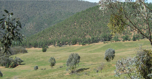
Rolling hills near the Snowy River Crossing
| Native vegetation Grassy woodland. Land use Mostly native vegetation, some land has been cleared for grazing. Soils The only site examined was on a moderate slope. The soils on other components were not examined. It is likely the soil profiles in the open depressions will be deeper and more yellow. There are likely to be heavier textured soils within this map unit. Because of their limited extent, only one auger hole was dug on the roadside reserve near the road exposure shown here. The surface soil is a dark brown (7.5YR3/4) coarse sandy loam that grades into a strong brown (7.5YR5/6) clayey coarse sand. The surface pH 7.0, and the subsoil pH 6.9. Decomposing granite was encountered at about 50 cm. | 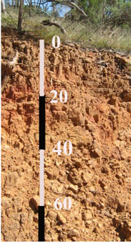 Roadside cutting: Geo. Ref. 0617700E 5908500N |
© State of Victoria (Agriculture Victoria) 1996 - .

This work, Victorian Resources Online, is licensed under a Creative Commons Attribution 4.0 licence. You are free to re-use the work under that licence, on the condition that you credit the State of Victoria (Agriculture Victoria) as author, indicate if changes were made and comply with the other licence terms.
The licence does not apply to ‘branding’ or some ‘images or photographs’ that may be owned by third parties. We ask you to seek prior approval to use images using the VRO feedback form. Access to higher quality images can also be provided on request.
This page was last updated on .