
Soils and vegetation in the Hartland Area
A reconnaissance soil and vegetation survey has been made of approximately 50,000 acres of Crown Land and Permanent State Forest known as the Hartland area in the parishes of Tildesley West, Tildesley East, Waygara and Newmerella, County Tambo. Subsequently a detailed soil survey was made of 1105 acres at Tostaree South within the reconnaissance survey. Interim reports on the reconnaissance and detailed surveys were presented to a Departmental Subcommittee on 6th October and 30th November, 1962 respectively. The "Soils and vegetation in the Hartland area - Report No. 34" was conducted in October 1962, by J. W. Newell of the former Department of Agriculture and B. J. Woodruff, of the the former Forest Commission.
To view the information PDF requires the use of a PDF reader. This can be installed for free from the Adobe website (external link).
 | (PDF 136KB) | 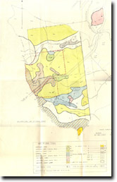 Hartland soil map (PDF 141KB) |
© State of Victoria (Agriculture Victoria) 1996 - .

This work, Victorian Resources Online, is licensed under a Creative Commons Attribution 4.0 licence. You are free to re-use the work under that licence, on the condition that you credit the State of Victoria (Agriculture Victoria) as author, indicate if changes were made and comply with the other licence terms.
The licence does not apply to ‘branding’ or some ‘images or photographs’ that may be owned by third parties. We ask you to seek prior approval to use images using the VRO feedback form. Access to higher quality images can also be provided on request.
This page was last updated on .