
Ambyne (Symbol: Ae)
EG224 | EG242 | EG246
Geology
Granite.
Landform
The Ambyne map unit encompasses rolling hills at an elevation range of about 200 to 800 m and a relief range of up to 300 m.
The granitic hills between Suggan Buggan and Cabanandra have been subdivided into the Ambyne map unit, which has slopes generally less than 32% and the Tubbut map unit, with slopes generally greater than 32%.
The Ambyne map unit may be subdivided into three components: gentle to moderate slopes, crests and concave open depressions.
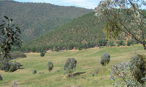
Cleared lower slopes near the Snowy River crossing near Suggan Buggan
Native vegetation
In the western part of the area, the native vegetation was mostly grassy dry forest, tending to grassy woodland west of Ambyne Crossing.
Land use
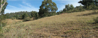
Mostly native vegetation, some land has been cleared for grazing.
Soils
Component 1: Soils on gentle to moderate slopes
The three soil profiles (EG224, EG242 and EG246) examined all had a high coarse sand component being described as coarse sandy loams to coarse sandy clay loam. Where the decomposing granite occurs at a shallow depth, the soils appear to be less acid with surface pH’s around 7.0. Where the depth to decomposing granite is deeper, the soils tend to be strongly to moderately acidic. This is probably because they are more deeply weathered.
Components 2 and 3: crests and concave open depressions.
No soil profiles were examined, but it is likely that those on the crests will be shallower and have occurrences of exposed rock.
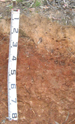
Site EG224
| Location: Ambyne | Geo. Ref. 0636700E 5900700N |
| Australian Soil Classification: Haplic, Eutrophic, Red CHROMOSOL | Red coarse sandy gradational soil |
| General landscape description: Rolling hills | |
| Geology: Granite | |
| Site description: Simple upper slope 15% south east | |
| Land use: Grazing | |
| Native vegetation: Grassy woodland | |
| Mapping unit: Ambyne (Component 1) |
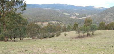
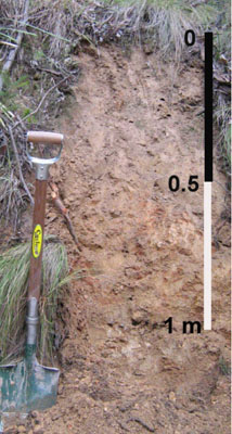
Photo taken about 1.5km north-west of Ambyne Crossing looking south-east along the Deddick River valley
Soil profile morphology
| Surface soil | 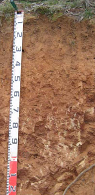 | ||
A11 | 0 – 18 cm | Dark reddish brown (5YR3/3); coarse sandy loam; weak fine (2 – 5 mm) granular structure; weak consistence dry; pH 7.2; clear change to: | |
A12 | 18 – 40 cm | Yellowish red (5YR4/6); coarse sandy loam; weak medium (10 – 20 mm) polyhedral structure; firm consistence dry; pH 7.3; abrupt change to: | |
| Subsoil | |||
B2 | 40 – 70 cm | Dark red (2.5YR3/6); coarse sandy clay loam; moderate coarse (20 – 50 mm) polyhedral structure; strong consistence dry; passing to very weak rock; pH 6.3; diffuse change to: | |
C | 70+ | Weak granitic rock becoming more frequent with depth. | |
Key profile features
| |||
Soil profile characteristics
| pH | Salinity rating | Sodicity | Dispersion | Slaking | |
| Surface soil (A1 horizon) | Slightly alkaline | Very low | Non sodic | None | Slakes partially |
| Subsoil (B1 horizon) | Slightly alkaline | Very low | Non sodic | None1 | Slakes considerably |
| Deeper subsoil (80-110 cm) | Slightly acid | Very low | Non sodic | None | Slakes considerably |
| Horizon | Depth cm | Field texture | pH water | pH CaCl2 | EC dS/m | Coarse sand % | Fine sand % | Silt % | Clay % | Field cap. % w/w | Wilt. point % w/w | PAW* water % w/w |
| A1 | 0-18 | CSL | 7.2 | 6.3 | <0.05 | 50 | 25 | 9 | 14 | 18.3 | 4.9 | 13.4 |
| A2 | 18-40 | CSL | 7.3 | 6.2 | <0.05 | 47 | 26 | 11 | 15 | 16.6 | 4.6 | 12.0 |
| B2 | 40-70 | CSCL | 6.3 | 5.0 | <0.05 | 40 | 20 | 14 | 22 | 22.2 | 9.0 | 13.2 |
| Depth | OrgC# | Total N | Free Fe2O3 | Exch. Al | Exchangeable cations cmol(+)/kg | Ca:Mg | ESP | ||||||
| cm | % | % | % w/w | ppm | Ca | Mg | K | Na | Total | H | CEC | ||
| 0-18 | 1.1 | <0.05 | <10 | 4.6 | 1.3 | 0.37 | <0.05 | 6.3 | 6.3 | 3.6 | |||
| 18-40 | 0.37 | <0.05 | <10 | 2 | 2 | 0.36 | 0.064 | 4.4 | 4.4 | 1 | 1 | ||
| 40-70 | 0.35 | <0.05 | 20 | 4.2 | 4.7 | 0.37 | 0.11 | 9.4 | 5.4 | 14.8 | 0.9 | 1 | |
Management considerations
Whole profile
- Plant available water capacity is considered to be low (estimated at 62 mm) for the top 65 cm of the soil profile.
- The low wilting points of each horizon to this depth (4.9, 4.6 and 9.0) indicates plants are able to use light rains when the soil is dry. Due to the low water storage capacity, plants will suffer moisture stress unless further rains occur.
- As mentioned above, the soils surface soils can hold little water, but plants can use light rains following a dry spell.
- The surface soil is slightly alkaline. Here the pH has no adverse implications for plant growth.
- The nutrient holding capacity of the surface horizons is low (based on the sum of the calcium, magnesium, potassium and sodium cations).
- The organic matter content of the surface soil is low. Increasing organic matter will help maintain soil fertility and water holding capacity.
- The potassium is at a moderate level for pastures and no response to added potassium would be expected.
- The slight increase in clay content is unlikely to restrict root penetration of deep rooted species until the decomposing granite is reached at about 70 cm.
| Location: Tubbut | Geo. Ref. 0638200E 5896400N |
| Australian Soil Classification: Eutrophic, Red CHROMOSOL | Red texture contrast soil |
| General landscape description: Rolling hills | |
| Geology: Granite | |
| Site description: Mid slope, south-east aspect, 10% slope | |
| Land use: Grazing | |
| Native vegetation: Grassy dry forest | |
| Mapping unit: Ambyne (Component 1) |
Soil profile morphology
| Surface soil |
 Road exposure down-slope from sampled site | |||||||||||||||||||||||||||||||||||||||||||||||||||||||||
A1
B2 | 0 – 20/35 cm 20/35 - 80+ cm | Brown (7.5YR4/4); coarse sandy loam, weak fine granular structure; firm consistence dry; pH 5.5; abrupt and wavy change: Reddish brown (2.5YR4/4); medium clay; moderate coarse polyhedral structure; very firm consistence dry; pH 6.0. | ||||||||||||||||||||||||||||||||||||||||||||||||||||||||
| ||||||||||||||||||||||||||||||||||||||||||||||||||||||||||
Site EG246
| Location: Chandlers Creek | Geo. Ref. 0694600E 5865700N |
| Australian Soil Classification: Bleached-Mottled, Eutrophic, Red KANDOSOL | Red coarse sandy gradational soil |
| General landscape description: Rolling to steep hills | |
| Geology: Granite | |
| Site description: Upper slope, 8% slope to north | |
| Land use: Native forest | |
| Native vegetation: Grassy dry forest | |
| Mapping unit: Ambyne (Component 1) |
Soil profile morphology
| Surface soil |
 | |||||||||||||||||||||||||||||||||||||||||||||||||||||||||
A11
B2 | 0 – 30 cm
| Pinkish grey (7.5YR6/2); coarse sandy clay loam; weak coarse granular structure; weak consistence moist; pH 5.2; gradual change to: Pinkish grey (7.5YR7/2); conspicuously bleached, coarse sandy loam; massive; weak consistence moist; gradual change to: Mottled pinkish grey, yellowish red (5YR4/6) and strong brown (7.5YR4/6); coarse sandy light clay; weak coarse polyhedral structure; firm consistence moist; pH 5.9. | ||||||||||||||||||||||||||||||||||||||||||||||||||||||||
Analysed by Industry and Investment NSW (2010) | ||||||||||||||||||||||||||||||||||||||||||||||||||||||||||
© State of Victoria (Agriculture Victoria) 1996 - .

This work, Victorian Resources Online, is licensed under a Creative Commons Attribution 4.0 licence. You are free to re-use the work under that licence, on the condition that you credit the State of Victoria (Agriculture Victoria) as author, indicate if changes were made and comply with the other licence terms.
The licence does not apply to ‘branding’ or some ‘images or photographs’ that may be owned by third parties. We ask you to seek prior approval to use images using the VRO feedback form. Access to higher quality images can also be provided on request.
This page was last updated on .