
Talbotville (Symbol: Te)
Geology
Palaeozoic sediments, mudstones, siltstones, sandstones and shales, occasionally metamorphosed.
Landform
In the context of this report, the Talbotville map unit encompasses rolling to steep hills with an elevation range of about 250 to 1,200 m. The slope gradients generally exceed 32% but are generally much steeper, commonly 40 – 70%. The relief ranges from 90 to over 300 m.
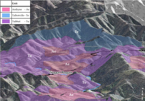
Computer generated image of the Suggan Buggan area. Talbotville: blue; Tubbut: purple and Ambyne: red. Vertical exaggeration 1:1.5.
Soils
Steep slopes, slow-weathering sedimentary rocks and rainfall inadequate enough to support vigorous and dense vegetation, give rise to active natural erosion and slow soil formation. Thus the soils tend to be shallow, stony, leached, acidic and weakly structured. Where areas have been denuded of vegetation, for example north of Smoking Hill, near Omeo, where it was removed to support the mining industry, the soils are prone to severe sheet erosion. On the valley floors where soil has accumulated, gully erosion can be quite severe.
Native vegetation
Shrubby dry forest with montane dry woodland at higher altitudes.
© State of Victoria (Agriculture Victoria) 1996 - .

This work, Victorian Resources Online, is licensed under a Creative Commons Attribution 4.0 licence. You are free to re-use the work under that licence, on the condition that you credit the State of Victoria (Agriculture Victoria) as author, indicate if changes were made and comply with the other licence terms.
The licence does not apply to ‘branding’ or some ‘images or photographs’ that may be owned by third parties. We ask you to seek prior approval to use images using the VRO feedback form. Access to higher quality images can also be provided on request.
This page was last updated on .