
Land Use
Land Use and Tenure
Most of the land in East Gippsland is in public ownership (about 87%), comprising mainly State Forest and National Park. With increased access by road and rail, settlement and selection laws became well entrenched in the west of the region and the practice of clearing dense forest for conversion to farmland began.
Agricultural settlement was largely confined to the better quality lands along the river valleys and plateaus, and although such areas provided good quality land, East Gippsland in general was never densely settled. Large areas remain in public ownership and the timber industry, rather than agriculture, has been the major economic force (C of A and State of Victoria 1996).
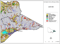 East Gippsland Land Use | This map is based on general statewide information obtained by satellite image interpretation (1991) and from other statewide datasets. It was initially prepared for State of Environment reporting in 1991and provides a general indication only, of land use and land tenure across East Gippsland. Data used to generate this map was derived from the land use layer (LANDUSE250) of the Department of Primary Industries Corporate Geospatial Data Library. |
Reference
Commonwealth of Australia (C of A) and State of Victoria (1996). East Gippsland Regional Forest Agreement: Comprehensive Regional Assessment. AGPS, Canberra.
© State of Victoria (Agriculture Victoria) 1996 - .

This work, Victorian Resources Online, is licensed under a Creative Commons Attribution 4.0 licence. You are free to re-use the work under that licence, on the condition that you credit the State of Victoria (Agriculture Victoria) as author, indicate if changes were made and comply with the other licence terms.
The licence does not apply to ‘branding’ or some ‘images or photographs’ that may be owned by third parties. We ask you to seek prior approval to use images using the VRO feedback form. Access to higher quality images can also be provided on request.
This page was last updated on .