Your gateway to a wide range of natural resources information and associated maps

Victorian Resources Online

East Gippsland Geomorphological Units map

Back to: East Gippsland Geomorphology

East Gippsland Geomorphological Units (PDF - 1152KB) The high resolution PDF file provided on this page can be viewed using the free Adobe PDF reader and this software can be installed from the Adobe website (external link). This PDF is provided with a high level of detail and with the intent that it should be printed at a high resolution.

This is a clickable map. Click on Geomorphological Unit in Legend for more information
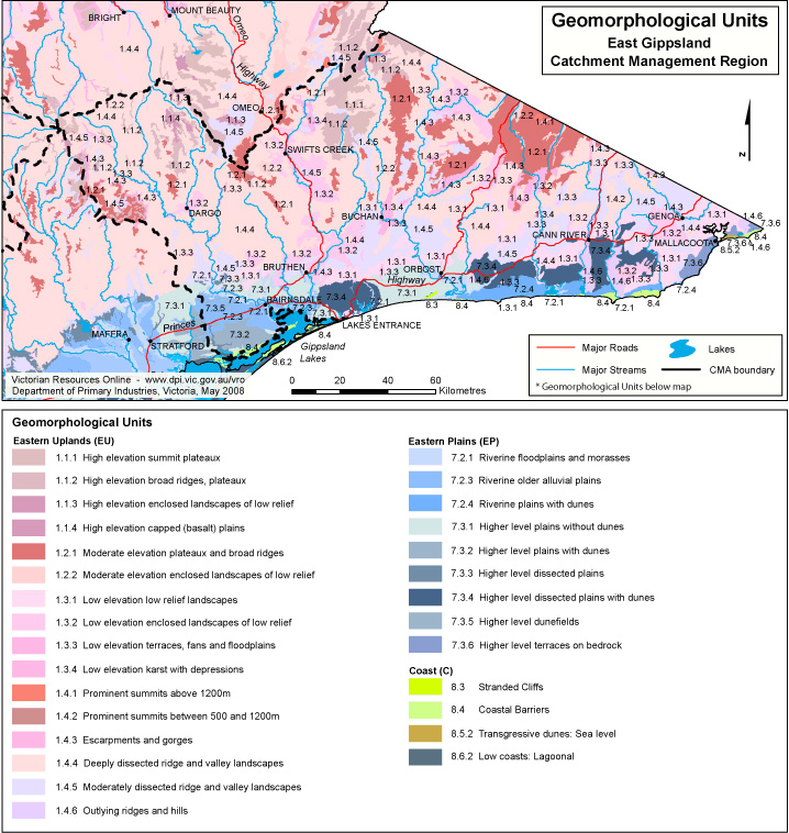
East Gippsland Geomorphic Unit

Geomorphological Units
Eastern Uplands
1.1.1 Summit plateaux (Mt Bogong, Baw Baw, Buffalo, Mt Wills)
1.1.2 Broad ridges, plateaux (Hotham-Lock Ridge, Mt Fainter Ridge, Barry Mountains, Davies Plain)
1.1.3 Enclosed landscapes of low relief (Horsehair Plain)
1.1.4 Capped (basalt) plains (Mt Jim-Bogong High Plains, Dargo Plains, Nunniong Plains)
1.2.1 Plateaux and broad ridges (Straghbogie, Koetong-Shelly, Errinundra, Kinglake, Olinda)
1.2.2 Enclosed landscapes of low relief (Fraser Tableland, Benambra)
1.3.1 Low relief landscapes at low elevation (Cann River south, Silvan, Templestowe)
1.3.2 Enclosed landscapes of low relief (Murmungee, Omeo, Dargo, Buldah)
1.3.3 Terraces, fans and floodplains (Kiewa Valley, Wonnangatta Valley)
1.3.4 Karst with depressions (Buchan)
1.4.1 Prominent summits above 1200 m (Mt Feathertop, Mt Howitt, Mt Buller)
1.4.2 Prominent summits between 500 and 1200 m (Pine Mountain, Mt Samaria, Mt Ellery, Ben Cruachan)
1.4.3 Escarpments, gorges (Mt Buffalo escarpment/gorge, Erinundra escarpment, Genoa, Mitchell, Moroka gorges and Snowy River gorges)
1.4.4 Deeply dissected ridge and valley landscapes (headwaters of major rivers such as the Wonnangatta, King and Kiewa Rivers, Mt Coopracambra)
1.4.5 Moderately dissected ridge and valley landscapes (Alexandra, Yea, Baranduda)
1.4.6 Outlying ridges and hills (Warby Range, Lurg Hills, Howe Range, Mt Dandenong)
Eastern Plains (EP)
7.2.1 Floodplains and morasses (Powlett, Tarwin, Moe, Latrobe, Thomson, Avon, Mitchell, Jack and Tarra Rivers, Dowd's Morass)
7.2.3 Older alluvial plains (Stratford, Briagolong)
7.2.4 Plains with dunes (west of the Perry River)
7.3.1 Plains without dunes (Darnum, Loy Yang, Giffard, Leongatha South, Munro plains)
7.3.2 Plains with dunes (Woodside, Longford, Munro plains with dunes)
7.3.3 Dissected plains (Yallourn North, Inverloch)
7.3.4 Dissected plains with dunes (Nowa Nowa)
7.3.5 Dunefields (Gormandale, Wonthaggi South, Liptrap)
7.3.6 Terraces on bedrock (Mallacoota)
Page top