
1.1.4 Capped (basalt) plains (Mt Jim-Bogong High Plains, Dargo Plains, Nunniong Plains)
1. Eastern Uplands (EU)
1.1.1 Summit plateaux (Mt Bogong, Baw Baw, Buffalo, Mt Wills)
1.1.2 Broad ridges, plateaux (Hotham-Lock Ridge, Mt Fainter Ridge, Barry Mountains, Davies Plain)
1.1.3 Enclosed landscapes of low relief (Horsehair Plain)
1.1.4 Capped (basalt) plains (Mt Jim-Bogong High Plains, Dargo Plains, Nunniong Plains)
| Parts of the high plains landscape are distinguished from those placed in Tier 1.1.1 because they have been capped by extensive flows of basalt belonging to the Older Volcanics (Palaeogene), as at Mt. Jim on the Bogong High Plains. The basalt flows are sub-horizontal, hard even when partly weathered, and commonly impart a rather flat topography in areas where remnants of them survive. Remnants of lava flows also outcrop at Basalt Hill and Ruined Castle on the Bogong High Plains and Mt. Loch (1 887 m) and Mt Higginbotham (1 789 m) on the Hotham – Loch Ridge. Other remnants in the Hotham Tablelands are Mt. Tabletop (1 588 m) and the Paw Paw Plains (c. 1 370-1 525 m) that extend towards Cobungra. An isolated small basalt-capped summit plateau is Mt. Useful (c. 1 200 m) on the Macalister-Thomson divide. The extensive Dargo High Plains (c. 1 380 m) is a broad tableland with a slight southward slope It is mainly composed of basalt, which fills an ancient deep valley. The valleys crossing are broad and shallow, with peaty flats and Sphagnum moss bogs common. |  |
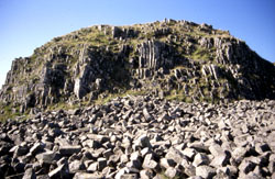
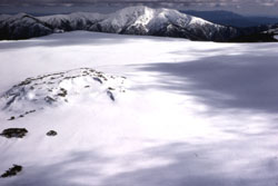 Basalt Hill |
Further east, the Nunniong and Gelantipy plateaus are also capped with basalt. Pre-basaltic river gravel with abundant quartz is exposed below the basalt in some areas, e.g. at Basalt Hill on the Bogong High Plains and beneath the Dargo High Plains. Despite the potentially more fertile soil parent-material (basalt), the vegetation of these areas is very similar to that of Tier 1.1.1, because the dominant environmental factor regulating the vegetation appears to be the climate and micro-climate. The soils are deep organic loams (Chernic Tenosols) to red or brown gradational soils (Dermosols). These soils are somewhat better supplied with plant nutrients than those on the other widespread rock types in the region, but are generally very well weathered and possibly well leached. They are often two layered; the boundary between the layers is often indicated by a stone-line that rests on the remnant the older soil or saprolite. Because of the high content of free iron oxide in these basaltic soils they may be classified as Ferrosols. |
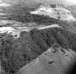 Broad Ridge Plateau | 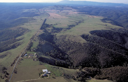 Bullengarook | 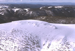 Mt Loch |
 Mt Loch |  Intermediate relief Toombullup with basalt cappings |
© State of Victoria (Agriculture Victoria) 1996 - .

This work, Victorian Resources Online, is licensed under a Creative Commons Attribution 4.0 licence. You are free to re-use the work under that licence, on the condition that you credit the State of Victoria (Agriculture Victoria) as author, indicate if changes were made and comply with the other licence terms.
The licence does not apply to ‘branding’ or some ‘images or photographs’ that may be owned by third parties. We ask you to seek prior approval to use images using the VRO feedback form. Access to higher quality images can also be provided on request.
This page was last updated on .