
Elevation
To the far north, near the border with New South Wales, is Mt Cobberas (1,833 metres above sea level) - the highest peak in the region. The Bowen mountains adjoin Mt Cobberas where Mt Tambo (1,432 m asl) lies just to the north of the intersection between the Tambo and Timbarra Rivers. Other peaks above 1,000 m are all within the northern part of the region and include Mt Baldhead (1,377 m asl), Mt Bowen (1,250 m asl), Mt Ellery (1,291 m asl) and Mt Kaye (1,001 m asl). Major peaks in the south of the region include Mt Elizabeth (942 m asl), Mt Tara (607 m asl), Mt McLeod (579 asl), Mt Cann (530 m asl) and Mt Buckle near the Murray River at 456 m asl (Duncan, 1982).
This Elevation map provides a broadscale overview of the relief across the region. It was created from the DEM250 dataset in the DPI Corporate Geospatial Data Library which was derived from an AUSLIG Digital Elevation Model of spot heights from 1:100 000 mapsheets and interpolated into a 500 metre cell size grid. | 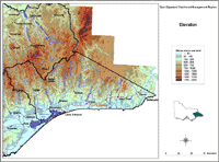 Elevation East Gippsland Region |
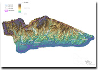
East Gippsland 3D Elevation Overview
Reference
Duncan, J.S. (1982). Atlas of Victoria. State of Victoria, Melbourne.
© State of Victoria (Agriculture Victoria) 1996 - .

This work, Victorian Resources Online, is licensed under a Creative Commons Attribution 4.0 licence. You are free to re-use the work under that licence, on the condition that you credit the State of Victoria (Agriculture Victoria) as author, indicate if changes were made and comply with the other licence terms.
The licence does not apply to ‘branding’ or some ‘images or photographs’ that may be owned by third parties. We ask you to seek prior approval to use images using the VRO feedback form. Access to higher quality images can also be provided on request.
This page was last updated on .