
Soil/Landform Unit 96
Landform Unit Description
Page top
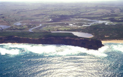 Estuary of the Gellibrand River with cliffs in the foreground at Prinectown |
0.34% of CMA region Many of the larger rivers in the wetter parts of the study area have extensive floodplains. Areas large enough to map exist on the Barham, Aire and Johanna rivers as well as the Gellibrand River and its tributaries. The landscape is generally flat, but irregular areas occur in the form of infilled meanders and minor terraces. In general, most areas are poorly drained, with stunted vegetation. However, closer to the drainage lines, the improved drainage often results in conditions more favourable for plant growth. Most of these alluvial flats have been cleared and provide valuable summer grazing for dairy farms along the valleys. Areas prone to waterlogging have been drained and improved pastures established. However, the remoteness of the valleys, set among very infertile surrounding land, has hampered agricultural development. |  |
 Alluvial terraces and plains near Princetown | 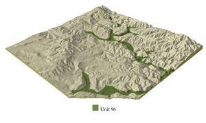 |
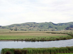
 | 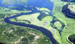 Meandering estuary and swamps of the Gellibrand River |
Component | 1 | 2 | 3 |
Proportion of soil-landform unit | 60% | 30% | 10% |
| CLIMATE Rainfall (mm) | Annual: 950-1100, lowest January (45), highest August (135) | ||
| Temperature (oC) | Annual: 13, lowest July (8), highest February (18) | ||
| Seasonal growth limitations | Temperature: less than 10oC (av.) June-September; July only near the coast Precipitation: less than potential evapotranspiration early November-late March, December-January near coast | ||
| GEOLOGY Age and lithology | Cretaceous fluvio-volcanic sandstone and conglomerate Quaternary clay, sand and gravel, Neogene fluvio-marine sand | ||
| Geomorphology | |||
| LANDUSE | Cleared areas: Dairy farming and water supply beef cattle grazing on improved pastures row and fodder cropping Uncleared areas: Water supply nature conservation; hardwood forestry for sawlogs | ||
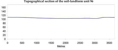
| TOPOGRAPHY Landscape | Alluvial floodplain of the Gellibrand, Aire and Barham Rivers | ||
| Elevation range (m) | 0-100 | ||
| Local relief (m) | 3 | ||
| Drainage pattern | Major meandering stream with deranged tributaries | ||
| Drainage density (km/km2) | 3.9 | ||
| Landform | Alluvial terraces | Streambanks, cut-off meanders, lower terraces | |
| Landform element | Poorly drained lower reaches | Well drained upper reaches | - |
| Slope and range (%) | 1 (0-2) | 0 (0-1) | 2 (0-5) |
| Slope shape | Linear | Linear | Convex |
| NATIVE VEGETATION Structure | Low woodland | Tall open forest | Tall open forest |
| Dominant species | E. obliqua, E. radiata, E. ovata | E. viminalis, E. obliqua, E. ovata, Acacia melanoxylon | E. viminalis, E. obliqua, Acacia melanoxylon |
| SOIL Parent material | Alluvial clay, silt and sand | Alluvial clay, silt and sand | Alluvial sand, silt and clay |
| Description (Corangamite Soil Group) | Grey gradational soils (34) | Brown sandy loam soils (34) | |
| Soil type sites | OTR733 | - | |
| Surface texture | Fine sandy loam | Fine sandy loam | Sandy loam |
| Permeability | Very low | Moderate | Very high |
| Depth (m) | >2 | >2 | >2 |
| LAND CHARACTERISTICS, POTENTIAL AND LIMITATIONS | High discharge rates along watercourses lead to flooding and siltation. High seasonal watertable and low permeabilities lead to seasonal waterlogging and soil compaction. | High discharge rates along watercourses lead to flooding and siltation. Weakly structured soils are prone to surface compaction. | High discharge rates along watercourses with weakly structured soils lead to stream bank erosion and siltration. High seasonal watertable in some areas leads to waterlogging. |
© State of Victoria (Agriculture Victoria) 1996 - .

This work, Victorian Resources Online, is licensed under a Creative Commons Attribution 4.0 licence. You are free to re-use the work under that licence, on the condition that you credit the State of Victoria (Agriculture Victoria) as author, indicate if changes were made and comply with the other licence terms.
The licence does not apply to ‘branding’ or some ‘images or photographs’ that may be owned by third parties. We ask you to seek prior approval to use images using the VRO feedback form. Access to higher quality images can also be provided on request.
This page was last updated on .