
OTR607
|
| OTR607 | 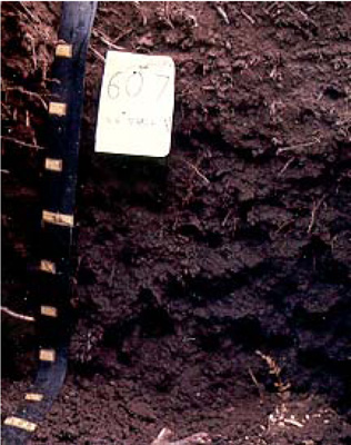 Humose-acidic, Magnesic, Black Kandosol | |
| Redwater Creek | |||
| Hills | |||
| Qauternary Alluvium | |||
| Terrace-alluvial flat | |||
| 0% | |||
| - | |||
Horizon | Depth (cm) | Description | ||
02 | 10–0 | Very dark greyish brown (10YR3/2); clay loam; weak subangular blocky structure; clear boundary to: | ||
A1 | 0–50 | Very dark greyish brown (10YR3/2); clay loam; weak subangular blocky structure; clear boundary to: | ||
A2 | 50–80 | Very dark greyish brown (10YR3/2); silty clay loam; weak subangular blocky structure boundary to: | ||
| 80+ | Watertable. | |||
| Management considerations | ||||
| Medium textured soils (loams) offer high agricultural versatility with very few physical limitations, but remains dependent on any chemical or depth restrictions. Friable surface soils (and subsoils) occur through the build up of dense organic matter (O2 horizon). Their acidic nature (pH < 5.0) restricts the uptake of certain nutrients as well as intolerance for some plant species (due in part to the increasing mobilisation of aluminium and manganese). Deficiencies of calcium, potassium and molybdenum are likely. | ||||
Analytical data
Site OTR607 | Sample depth | pH | EC | NaCl | Ex Ca | Ex Mg | Ex K | Ex Na | Ex Al | Ex acidity | FC (-10kPa) | PWP (-150kPa) | KS | FS | Z | C | |
Horizon | cm | H2O | CaCl2 | dS/m | % | cmolc/kg | cmolc/kg | cmolc/kg | cmolc/kg | mg/kg | cmolc/kg | % | % | % | % | % | % |
O2 | 10–0 | 4.4 | N/R | 0.290 | 0.026 | 0.2 | 1.3 | 0.7 | 1.3 | N/R | N/R | N/R | N/R | 0.2 | 6 | 23 | 38 |
A1 | 0–10 | 4.5 | N/R | 0.270 | 0.023 | 0.06 | 1.2 | 0.7 | 1.1 | N/R | N/R | N/R | N/R | 0.4 | 27 | 27 | 22 |
A1 | 10–20 | 4.6 | N/R | 0.240 | 0.023 | 0.08 | 1.1 | 0.7 | 1.0 | N/R | N/R | N/R | N/R | <1 | 12 | 35 | 26 |
A2 | 50–70 | 5.0 | N/R | 0.076 | 0.010 | 0.04 | 1.0 | 0.6 | 0.8 | N/R | N/R | N/R | N/R | <1 | 17 | 39 | 27 |
© State of Victoria (Agriculture Victoria) 1996 - .

This work, Victorian Resources Online, is licensed under a Creative Commons Attribution 4.0 licence. You are free to re-use the work under that licence, on the condition that you credit the State of Victoria (Agriculture Victoria) as author, indicate if changes were made and comply with the other licence terms.
The licence does not apply to ‘branding’ or some ‘images or photographs’ that may be owned by third parties. We ask you to seek prior approval to use images using the VRO feedback form. Access to higher quality images can also be provided on request.
This page was last updated on .