
CLRA41
Location: Lake Victoria (Shell Road), Ocean Grove District, Bellarine Peninsula
Australian Soil Classification: Melanic, Regolithic, Bleached-Leptic TENOSOL
General Landscape Description: Dune crest of coastal dunes unit.
Geology: Quaternary coastal dune deposits: aeolian coastal and inland dunes; dune sand, some swamp deposits.
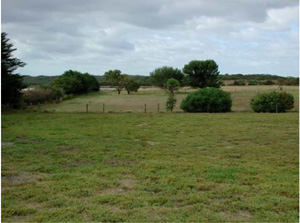
CLRA41 Landscape. Coastal low land dune field
Soil Profile Morphology:
Surface Soil
A1 | 0–10 | Dark grey (10YR4/1); sand; apedal single grain structure; sandy fabric; very weak consistence dry; non-calcareous, pH 7.5; clear boundary to: | 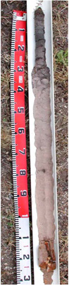 CLRA41 Profile | |||
2A11 | 10–20 | Very dark grey (2.5Y3/1); loamy sand; apedal single grain structure; earthy fabric; very weak consistence dry; non-calcareous, pH 8.0; clear boundary to: | ||||
2A12 | 20–30 | Brown (7.5YR5/2); sand; apedal single grain structure; earthy fabric; very weak consistence dry; non-calcareous, pH 7.0; sharp boundary to: | ||||
2A21 | 30–75 | Greyish brown (10YR5/2), conspicuously bleached light grey (10YR7/2 dry); sand; apedal single grain structure; sandy fabric; loose consistence dry; non-calcareous; pH 7.5; diffuse boundary to: | ||||
2A22 | 75–110 | Brown (10YR5/3), light brownish grey (10YR6/2 dry); sand; apedal single grain structure; sandy fabric; loose consistence dry; slightly calcareous, pH 8.0; sharp boundary to: | ||||
Subsoil | ||||||
2B2 | 110–125 | Strong brown (7.5YR5/6); sandy clay; common large angular calcarenite coarse fragments; weak medium prismatic structure; smooth fabric; very firm moderately consistence moist; few distinct other cutans; very highly calcareous, pH 9.5. | ||||
Management Considerations:
- This is a neutral to alkaline sandy soil with a heavier subsoil at depth (125cm). Sandy topsoils generally have poor plant water holding capacity and poor nutrient holding capacity and due to the low level of bonding between soil particles are prone to wind, sheet and rill erosion (depending on organic matter content and vegetative cover). This site has an organic surface soil which is protecting the material with loose/weak consistence below. These soils may be hydrophobic (in conjunction with organic coatings) when dry, taking time to reabsorb moisture. It is helpful to reduce the wetting/drying cycle and as well as increase organic matter and clay content (clay spreading is practiced in western Victoria). Sandy topsoils do however drain rapidly. Maintenance of a vegetative cover is important.
- The bleached A2 horizons (or subsurface soils) are a major feature here as are many of soils within the Corangamite Catchment Management Authority (CMA) region. They are an indication of restricted drainage, poor soil structure (often massive) and low organic matter, nutrient and water holding capacity, nearly always in conjunction with a restrictive soil below such as a clayey soil or a pan (eg. coffee rock), though here they are still alkaline. These bleached horizons may act as conduit for subsurface flow, particularly on sloping ground. If the soil is dispersive then gypsum application would be suitable, while increasing organic matter and maintaining vegetative cover is important.
Profile Described By: David Rees & Grant Boyle (December 2002).
© State of Victoria (Agriculture Victoria) 1996 - .

This work, Victorian Resources Online, is licensed under a Creative Commons Attribution 4.0 licence. You are free to re-use the work under that licence, on the condition that you credit the State of Victoria (Agriculture Victoria) as author, indicate if changes were made and comply with the other licence terms.
The licence does not apply to ‘branding’ or some ‘images or photographs’ that may be owned by third parties. We ask you to seek prior approval to use images using the VRO feedback form. Access to higher quality images can also be provided on request.
This page was last updated on .