
Soil/Landform Unit 26
Landform Unit Description
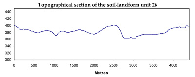
Page top
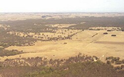 The sharp and steep slopes of this unit lie in the east of the catchment lining the Moorabool River |
0.05% of CMA region This unit of scarp slopes is underlain by Cainozoic gravel within the dissected Western Uplands. This single scarp unit is on the southern edge of an undulating plain and rise catena formed on older (Palaeozoic) sediments (Unit 9) with a younger sedimentary (Neogene) capping in places. The soils influenced by basaltic colluvium are acidic black cracking clays (Vertosols) with some shallow brown loams (Dermosols) associated with quartzite outcropping. The clay soils are strongly structured but susceptible to sheet erosion due to slope. Depth limitations include water holding capacity as well as stoniness and aggregate stability in the case of the loams. Land use in this lower annual rainfall part of the catchment is generally extensive grazing and occasional cropping. |  |
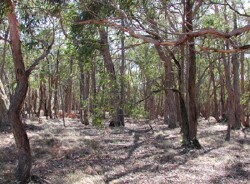 Remnant vegetaton stand south of Clarendon |  |
 |
Component | 1 | 2 |
Proportion of soil-landform unit | 90% | 10% |
| CLIMATE Rainfall (mm) | Annual: 710 | |
| Temperature (oC) | Minimum 7, Maximum 18 | |
| Precipitation less than potential evapotranspiration | October-March | |
| GEOLOGY Age and lithology | ||
| Geomorphology | ||
| LANDUSE | Uncleared: Nature conservation; hardwood and softwood plantations Cleared: Sheep and beef cattle grazing; gravel extraction; gravel and sediments | |
| TOPOGRAPHY Landscape | Undulating rises | |
| Elevation range (m) | 354-420 | |
| Local relief (m) | 10 | |
| Drainage pattern | Dendritic | |
| Drainage density (km/km2) | 4.4 | |
| Landform | Rises | |
| Landform element | Scarp | Outcrop |
| Slope and range (%) | 30 (15-60) | 1 (0-3) |
| Slope shape | Straight-concave | Straight |
| NATIVE VEGETATION Structure | Open forest | Open forest |
| Dominant species | E. obliqua, E. viminalis, E. radiata | E. obliqua, E. viminalis, E. radiata |
| SOIL Parent material | Alluvial and colluvial basalt and unconsolidated gravels, sands and clays | Quartzite |
| Description (Corangamite Soil Group) | Black cracking clay soils (39) | Brown shallow loam (earth) soil (25) |
| Soil type sites | ||
| Surface texture | Clay | Loam |
| Permeability | Moderate | High |
| Depth (m) | 1 | 0.1 |
| LAND CHARACTERISTICS, POTENTIAL AND LIMITATIONS | Steep slopes combined with overland flow can cause sheet and rill erosion. | Exposure can lead to wind erosion. Soils have shallow effective rooting depth. Overland flow can cause seet and rill erosion. |
© State of Victoria (Agriculture Victoria) 1996 - .

This work, Victorian Resources Online, is licensed under a Creative Commons Attribution 4.0 licence. You are free to re-use the work under that licence, on the condition that you credit the State of Victoria (Agriculture Victoria) as author, indicate if changes were made and comply with the other licence terms.
The licence does not apply to ‘branding’ or some ‘images or photographs’ that may be owned by third parties. We ask you to seek prior approval to use images using the VRO feedback form. Access to higher quality images can also be provided on request.
This page was last updated on .