
SW38
|
| SW38 | 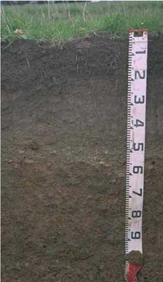 Ferric-Sodic, Mesotrophic, Grey CHROMOSOL | |
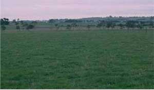
| Irrewillipe | |||
| Gently undulating plain | |||
| Tertiary - Moorabool Viaduct Formation. | |||
| Gentle slope | |||
Horizon | Depth (cm) | Description | ||
A1 | 0-15 | Very dark brown (10YR2/2); light fine sandy clay loam; moderate coarse polyhedral, parting to moderate medium polyhedral structure; weak consistence moist; pH 6.1: | ||
A21 | 15-45 | Dark brown (10YR3/3), sporadically bleached; rusty root channel mottling; light fine sandy clay loam; weak medium blocky, parting to moderate medium blocky structure; weak consistency moist; pH 5.7: | ||
A22 | 45-55 | Dark brown (10YR4/3); fine sandy clay loam; contains very many (80%) medium and coarse (4-20 mm); ferruginous nodules; pH 6.4: | ||
B21 | 55-90 | Dark brown (7.5YR4/2) with many strong brown (7.5YR5/8) mottles; light medium clay; strong medium blocky, parting to strong fine polyhedral structure; firm to strong consistence moist; contains a few (5-10%) medium and coarse (4-20 mm) ferruginous nodules pH 6.7: | ||
B22 | 90+ | Light brownish grey (10YR6/2) with reddish yellow (7.5YR6/8) and red (2.5YR4/8) mottles; medium clay; strong medium blocky, parting to strong fine polyhedral structure; firm consistence moist; contains a few (5-10%) ferruginous nodules; pH 6.8. | ||
| Management considerations | ||||
| Friable surface soils (and subsoils) occur where there is a build up of organic matter, (and to some extent iron rich clay complexes) generally in cooler wetter areas (less extreme wetting and drying cycling). Bleached A2 horizons (or subsurface soils) are a major feature of many of soils within the Corangamite CMA region. They are an indication of restricted drainage, poor soil structure (often massive) and low organic matter, nutrient and water holding capacity, nearly always in conjunction with a restrictive soil below such as a clayey soil or a pan (e.g. coffee rock). These bleached horizons may act as conduit for subsurface flow, particularly on sloping ground. If the soil is dispersive then gypsum application would be suitable, while increasing organic matter and maintaining vegetative cover is important. Ferruginous and Ferromanganiferous nodules, concretions and pans can restrict root penetration and limit available water holding capacity where there are sufficient amounts, often forming a discontinuous or continuous pan where concentrated (>50%). They are also an indication of a periodic waterlogging. Either shallow rooted species can be planted to avoid the nodules, subsoil drainage may need to be considered, possibly in conjunction with deeper rooted plants which could puncture the nodule layer and access available water and nutrients stored below. Mottled subsoils are common and are an indication of periodic waterlogging, particularly if the mottles are pale (low oxygen conditions). Some brighter mottling may be due to past soil mixing and clay alluviation. Improved drainage, with the application of gypsum for sodic subsoils may be beneficial. | ||||
Analytical data
Site SW38 | Sample depth | pH | EC | NaCl | Ex Ca | Ex Mg | Ex K | Ex Na | Ex Al | Ex acidity | FC (-10kPa) | PWP (-150kPa) | KS | FS | Z | C | |
Horizon | cm | H2O | CaCl2 | dS/m | % | cmolc/kg | cmolc/kg | cmolc/kg | cmolc/kg | mg/kg | cmolc/kg | % | % | % | % | % | % |
A1 | 0-15 | 6.1 | 5.4 | 0.08 | N/R | 6 | 0.4 | 0.2 | 0.05 | N/R | N/R | 29 | 9.3 | 7 | 54 | 17 | 14 |
A21 | 15-45 | 5.7 | 4.9 | 0.07 | N/R | 2.9 | 0.3 | 0.05 | 0.05 | N/R | N/R | 27.4 | 6.7 | 9 | 55 | 19 | 14 |
A22 | 45-55 | 6.4 | 5.6 | 0.05 | N/R | 1.4 | 0.9 | 0.05 | 0.05 | N/R | N/R | 25.9 | 9.1 | 17 | 47 | 15 | 21 |
B21 | 55-90 | 6.7 | 6 | 0.08 | N/R | 4.6 | 6 | 0.2 | 0.6 | N/R | N/R | 52.8 | 31.4 | 2 | 12 | 5 | 78 |
B22 | 90+ | 6.8 | 6 | 0.07 | N/R | 3.9 | 5.8 | 0.1 | 0.6 | N/R | N/R | 48.4 | 27.5 | 3 | 18 | 9 | 72 |
© State of Victoria (Agriculture Victoria) 1996 - .

This work, Victorian Resources Online, is licensed under a Creative Commons Attribution 4.0 licence. You are free to re-use the work under that licence, on the condition that you credit the State of Victoria (Agriculture Victoria) as author, indicate if changes were made and comply with the other licence terms.
The licence does not apply to ‘branding’ or some ‘images or photographs’ that may be owned by third parties. We ask you to seek prior approval to use images using the VRO feedback form. Access to higher quality images can also be provided on request.
This page was last updated on .