
Soil/Landform Unit 37
Landform Unit Description
Page top
 Gently undulating plains graduating east into the gently undulating rises and long slopes |
0.17% of CMA region The basaltic plains and rises that occur in the Midlands of the Western Uplands are located south of Ballan and south-east of Skipton. These separate fragments are characterised by long gently undulating rises with Plains Grassy Woodlands and Plains Grassland as the major vegetation classes. The gently undulating rises coincide with the gently undulating plains of Unit 41. The dissection has produced gentle rises that have been derived from weathering of Pleistocene basalt. Soils of the rises consists of texture contrast soils with areas of gilgai microrelief that are usually found to commonly be mottled black texture contrast soils with minor occurrences of other mottled texture contrast soils. The soils on the mounds and in the depressions are similar apart from those on the mounds having shallower surfaces. A few scattered surface stones may occur on the upper slopes and crests. Land use includes beef cattle and sheep grazing, water supply, softwood plantations and residential development around the smaller communities. Erosion hazards are minor including sheet and rill erosion on steeper slopes and gully erosion in depressions where sodic subsoils prevail. Areas with shallow stony gradational soils are susceptible to leaching of nutrients, and compaction is a problem on the flatter gilgaied areas. | 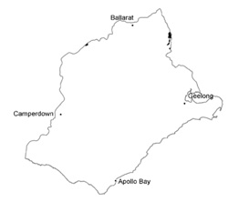 |
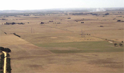
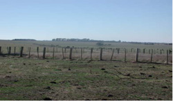
 Long gentle slopes of the basalt rises near Ballan | 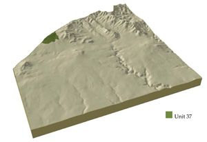 |
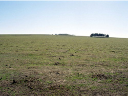
|  Grazing by beef cattle is one of many land uses |
Component | 1 | 2 | 3 | 4 | 5 |
Proportion of soil-landform unit | 90% | 2% | 2% | 3% | 3% |
| CLIMATE Rainfall (mm) | Annual: 690 | ||||
| Temperature (oC) | Minimum 7, Maximum 18 | ||||
| Precipitation less than potential evapotranspiration | October-March | ||||
| GEOLOGY Age and lithology | Pleistocene basalt | ||||
| Geomorphology | |||||
| LANDUSE | Uncleared: Nature conservation Cleared: Beef cattle and sheep grazing; water supply; cropping (cereal); softwood plantations; residential development | ||||
| TOPOGRAPHY Landscape | Gently undulating plains with a scarp beside main creek including channel | ||||
| Elevation range (m) | 313-533 | ||||
| Local relief (m) | 2 (on plains), 45 (at the scarp) | ||||
| Drainage pattern | Dendritic | ||||
| Drainage density (km/km2) | 1.3 | ||||
| Landform | Depression | Scarp with local rock outcrop | Creek bed | ||
| Landform element | Long gentle upper slopes | Depression | Stony rise | Slope | Floodplain |
| Slope and range (%) | 1 (1-3) | 1 (1-2) | 3 (2-5) | 13 (7-25) | 2 (0-3) |
| Slope shape | Straight | Straight | Convex | Convex | Straight |
| NATIVE VEGETATION Ecological Vegetation Class | Plains Grassy Woodland (0.5%), Plains Grassland (0.2%) | ||||
| Dominant species | E. ovata, E. viminalis, E. rubida, E. obliqua | E. viminalis, E. ovata | E. viminalis, E. ovata | ||
| SOIL Parent material | In situ weathered basalt | Alluvium | In situ weathered basalt | In situ weathered basalt | Unconsolidated sedimentary and in situ weathered basalt |
| Description (Corangamite Soil Group) | Mottled brown, grey or yellow, grey sodic texture contrast soil, coarse structure (35) | Black cracking clay soil, coarse structure (31) | Red shallow, stony gradational soil (40) | Black clay soil, coarse strucutre (39) | |
| Soil type sites | |||||
| Surface texture | Clay loam | Clay | Clay loam | Clay loam | Clay |
| Permeability | Moderate to low | Moderate | High | High | Low |
| Depth (m) | 1.5 | 1.5 | 0.5 | 1 | 1.5 |
| LAND CHARACTERISTICS, POTENTIAL AND LIMITATIONS | Hardsetting surfaces and slowly permeable subsoils result in significant overland flow. Sheet and rill erosion also occur from this overland flow. Soil compaction is also a limitation for soils with shallow topsoils. Periodic waterlogging also occurs. | Clay soils beside creeks are prone to periodic waterlogging. Streambank undercutting and stream bank erosion common. Slowly permable subsoils are also quite sodic and prone to gully erosion. | Overland flow, nutrient leaching and decline all reflect highly permeable soils. Sheet erosion is common with excessive rainfall events. | Steep slopes and hardsetting surfaces result in significant overland flow. Sheet and rill erosion also occur from this overland flow. | Poorly drained site with a low permeability (waterlogging). Streambank erosion is possible with large rainfall events. |
© State of Victoria (Agriculture Victoria) 1996 - .

This work, Victorian Resources Online, is licensed under a Creative Commons Attribution 4.0 licence. You are free to re-use the work under that licence, on the condition that you credit the State of Victoria (Agriculture Victoria) as author, indicate if changes were made and comply with the other licence terms.
The licence does not apply to ‘branding’ or some ‘images or photographs’ that may be owned by third parties. We ask you to seek prior approval to use images using the VRO feedback form. Access to higher quality images can also be provided on request.
This page was last updated on .