
Soil/Landform Unit 41
Landform Unit Description
Page top
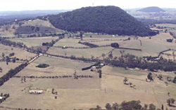 Undulating rises on this southern side of Mount Bininyong have red friable gradational soils. This area is becoming increasingly popular and pressures for subdivision increase as residential development expands around Buninyong |
0.01% of CMA region The undulating basaltic rises associated with Mount Buninyong form part of sequence of volcanic landforms within the Midlands of the Western Uplands. These rises are characterised by plains and slopes that lie on the southern margin of Mount Buninyong. The rises support the vegetation classes Valley Grassy Forest, Plains Grassy Woodland and Grassy Dry Forest with the dominant species being manna gum (E. viminalis), narrow leaf peppermint (E. radiata) and messmate stringybark (E. obliqua). This unit is an intricate mixture of plains and slopes. The slopes provide dark red gradational soils while the lower slopes with unconsolidated sediments have a mixture of sodic texture contrast soils. Some of the footslopes of Mount Buninyong also occur in this unit. Agricultural land use is quite diverse and includes beef cattle and sheep grazing, hardwood forestry and water supply. Pressures from residential development may see this become the primary land use in future years. Erosion hazards are minimal. Areas with shallow stony gradational soils are susceptible to leaching of nutrients, and compaction is a problem on the lower slopes and depressions. |  |
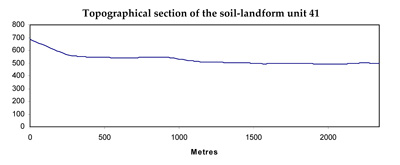
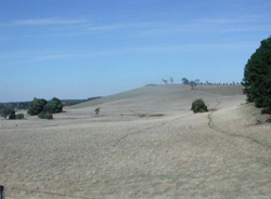 The undulating rises are mainly used for grazing but potentially can be used for a suite of land uses | 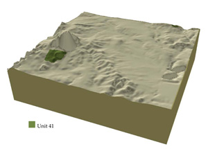 |
|
Component | 1 | 2 | 3 | 4 |
Proportion of soil-landform unit | 22% | 22% | 22% | 34% |
| CLIMATE Rainfall (mm) | Annual: 830 | |||
| Temperature (oC) | Minimum 7, Maximum 17 | |||
| Precipitation less than potential evapotranspiration | November-March | |||
| GEOLOGY Age and lithology | Pleistocene basalt, scoria tuff, Orodivican marine sandstone and shale and minor Quaternary alluvium | |||
| Geomorphology | ||||
| LANDUSE | Uncleared: Nature conservation; passive and active recreation, water supply, hardwood forestry Cleared: Beef cattle and sheep grazing, cropping, residential development | |||
| TOPOGRAPHY Landscape | Undulating rises | |||
| Elevation range (m) | 482-553 | |||
| Local relief (m) | 180 | |||
| Drainage pattern | Dendritic | |||
| Drainage density (km/km2) | 2.6 | |||
| Landform | Undulating plains and rise | Volcanic cone | ||
| Landform element | Crest and upper slope | Mid slope | Lower slopes | Slope and crest |
| Slope and range (%) | 3 (1-6) | 4 (2-7) | 1 (1-2) | 25 (5-40) |
| Slope shape | Convex | Straight | Concave | Straight |
| NATIVE VEGETATION Ecological Vegetation Class | Valley Grassy Forest (2.3%); Plains Grassy Woodland (2.2%); Grassy Dry Forest (1.1%) | |||
| Dominant species | E. viminalis, E. radiata, E. obliqua | E. viminalis, E. radiata | ||
| SOIL Parent material | In situ weathered basalt | In situ weathered basalt | In situ weathered basalt | In situ weathered basalt |
| Description (Corangamite Soil Group) | Red gradationa soil, fine structure (40) | Dark red gradational soil, fine structure (40) | Stony red gradational soil (40) | |
| Soil type sites | ||||
| Surface texture | Clay loam | Loam | Clay loam | Clay loam |
| Permeability | High | High | Moderate to low | High |
| Depth (m) | 2 | 1.5 | 1.5 | 1 |
| LAND CHARACTERISTICS, POTENTIAL AND LIMITATIONS | Slope exposure, leaching, overland flow, sheet erosion and nutrient decline are very minor. These soils have a high agricultural versatility. | Slope exposure, leaching, overland flow, sheet erosion and nutrient decline are very minor. These soils have a high agricultural versatility. | Low permeability subsoils combined with hardsetting sufaces often result in waterlogging and soil compaction. | Steep slopes, overland flow, sheet erosion and nutrient decline are very minor. These soils have a high agricultural versatility |
© State of Victoria (Agriculture Victoria) 1996 - .

This work, Victorian Resources Online, is licensed under a Creative Commons Attribution 4.0 licence. You are free to re-use the work under that licence, on the condition that you credit the State of Victoria (Agriculture Victoria) as author, indicate if changes were made and comply with the other licence terms.
The licence does not apply to ‘branding’ or some ‘images or photographs’ that may be owned by third parties. We ask you to seek prior approval to use images using the VRO feedback form. Access to higher quality images can also be provided on request.
This page was last updated on .