
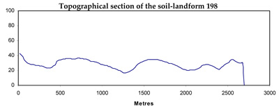
Soil/Landform Unit 198
Landform Unit Description
Page top
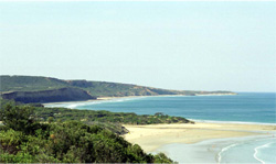
 Longitudinal coastal dunes with back swamps and estuaries near Breamlea |
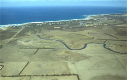
0.07% of CMA region Along the coast from Breamlea to Eastern View, coastal dunes occur discontinuously. In some localities a primary and a secondary dune form a thin barrier between the sea and the Paleogene sediments, but in the locality of Point Impossible the dune system is more complex and extensive. The foredune and secondary dune material is aeolian sand and shell grit. On older dunes, mobilisation of calcium carbonate has resulted in the formation of calcarenite, which may outcrop on blowouts or steep slopes. Away from these calcarenite pavements, the soils are freely drained calcareous sands. The exposed calcarenite pavements may support red calcareous gradational soils, but extensive sheet erosion has removed most of this material. Recreation and access to the foreshore are the main land uses. Some buildings have been sited in these dunes at Breamlea and Fairhaven. Native grasses and shrubs that colonise these dunes are very sensitive to disturbance and once devoid of vegetative cover, wind erosion is likely to occur. Hand planting of Ammophila arenaria has been necessary to restabilise many areas. |  |
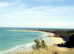 Point Roadknight | 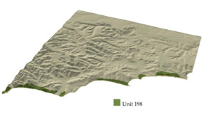 |
 |  Coastal cliffs and dunes |
Component | 1 | 2 | 3 | 4 | 5 |
Proportion of soil-landform unit | 20% | 50% | 25% | 2% | 3% |
| CLIMATE Rainfall (mm) | Annual: 600–750, lowest January (30), highest August (75) | ||||
| Temperature (oC) | Annual: 14, lowest July (10), highest February (18) | ||||
| Seasonal growth limitations | Temperature: less than l 0oC (av.) July Precipitation: less than potential evapotranspiration mid October–early April | ||||
| GEOLOGY Age and lithology | Quaternary coastal aeolian sand dunes, alluvium and shell grit | Cemented Paleogene marine clay, fluvial sand and gravel deposits (calcarenite and travertine) | |||
| Geomorphology | |||||
| LANDUSE | Uncleared areas: Passive and active recreation; foreshore access; nature conservation; sand extraction Minor cleared areas: Recreational facilities; refuse tip; foreshore access; residential | ||||
| TOPOGRAPHY Landscape | Longitudinal coastal dunes to the east of the Otway Range | ||||
| Elevation range (m) | 0–25 | ||||
| Local relief (m) | 15 | ||||
| Drainage pattern | - | ||||
| Drainage density (km/km2) | 1.7 | ||||
| Landform | Foredunes | Shifting dunes | Older more stable dunes | Interdune corridors | |
| Landform element | Windward exposed slope | Leeward and windward slopes | Gentler slope | Steeper slope | - |
| Slope and range (%) | 40 (10–65) | 30 (5–65) | 9 (0–20) | 15 (5–30) | 3 (0–7) |
| Slope shape | Irregular | Irregular | Convex | Linear | Concave |
| NATIVE VEGETATION Ecological Vegetation Class | Tussock grassland | Open heath | Low woodland | Low woodland | Possibly open heath |
| Dominant species | Spinifex hirsutus, Tetragonia tetragonioides | Helichrysum paralium, Leucopogon parviflorus | Melaleuca lanceolata, Leptospermum laevigatum, Leucopogon parviflorus | Melaleuca lanceolata, Leucopogon parviflorus, Acacia longifolia | Helichrysum paralium |
| SOIL Parent material | Coarse sand, shell grit | Coarse sand, shell grit | Coarse sand, shell grit | Calcarenite coarse sand | Calcarenite, travertine |
| Description (Corangamite Soil Group) | Brown, grey and yellow calcareous sand soils (12) | Brown, grey and yellow calcareous sand soils (12) | Brown calcareous sand soils (12) | Stony black calcareous sand soils (8) | Red calcareous gradational soils (24) |
| Soil type sites | |||||
| Surface texture | Coarse sand | Coarse sand | Loamy sand | Loamy sand | Sandy loam |
| Permeability | Very high | Very high | Very high | Moderate | Very low |
| Depth (m) | >2 | >2 | >2 | >2 | 0.3 |
| LAND CHARACTERISTICS, POTENTIAL AND LIMITATIONS | Marine erosion and accretion occur seasonally. Native vegetation is sensitive to trampling and disturbance. Weakly structured sands are prone to wind erosion. Low inherent fertility and high permeability lead to nutrient decline. | Native vegetation is sensitive to trampling and disturbance. Weakly structured sands are prone to wind erosion. Low inherent fertility and high permeability lead to nutrient decline. | Weakly structured sands are prone to wind erosion. Low inherent fertility, high alkalinity and high permeability lead to nutrient decline. | Weakly structured sands with restricted drainage on steep slopes are prone to sheet erosion. Low inherent fertility and high alkalinity lead to nutrient decline. | Low permeability and weak structure lead to sheet erosion, exposing calcarenite pavement. |
© State of Victoria (Agriculture Victoria) 1996 - .

This work, Victorian Resources Online, is licensed under a Creative Commons Attribution 4.0 licence. You are free to re-use the work under that licence, on the condition that you credit the State of Victoria (Agriculture Victoria) as author, indicate if changes were made and comply with the other licence terms.
The licence does not apply to ‘branding’ or some ‘images or photographs’ that may be owned by third parties. We ask you to seek prior approval to use images using the VRO feedback form. Access to higher quality images can also be provided on request.
This page was last updated on .