
Soil/Landform Unit 193
Landform Unit Description
Page top
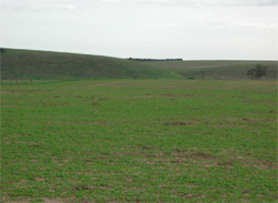
 Gently undulating depositional plain west of Murgheboluc |
0.01% of CMA region A gently undulating plain east of Inverleigh is a member of an alluvial complex within the Western Plains. The unit is characterised by a combination of terraces, billabongs, drainage depressions and streambanks. Neogene sedimentary plains to the north (Unit 6b) and the Barwon River to the south surround this small single entity unit. The remnant vegetation class of the unit is Plains Grassy Woodland with majestic Eucalyptus camaldulensis lining these drainage depressions, drainage lines and billabongs. The soils are sodic brown and red texture contrast soils (Sodosols) on the higher older terraces, more friable gradational soils (Dermosols) on the younger lower terraces, and cracking clays (Vertosols) in the depressions. Rainfall is relatively low in this area. Land use is grazing with some cropping, as well as residential use. The terraces have moderate to slow site drainage, the sodic upper terraces may have structure problems as well as susceptibilities to compaction and sheet erosion. The lower areas are susceptible to waterlogging. |  |
 The short steep slopes and scarps are particularly vulnerable to water erosion (gully and tunnel, sheet and rill) | 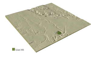 |
 |
Component | 1 | 2 | 3 | 4 |
Proportion of soil-landform unit | 45% | 35% | 5% | 15% |
| CLIMATE Rainfall (mm) | Annual: 530 | |||
| Temperature (oC) | Minimum 9, Maximum 20 | |||
| Precipitation less than potential evapotranspiration | September–April | |||
| GEOLOGY Age and lithology | Quaternary alluvium - clay, sand and gravel | |||
| Geomorphology | ||||
| LANDUSE | Uncleared: Nature conservation; passive recreation Cleared: Residential, grazing, some cropping | |||
| TOPOGRAPHY Landscape | Gently undulating plain | |||
| Elevation range (m) | 36–42 | |||
| Local relief (m) | 5 | |||
| Drainage pattern | Dendritic | |||
| Drainage density (km/km2) | 2.4 | |||
| Landform | Terrace 2 | Terrace 1 | Depressions and billabongs in Terrace 1 | River channel bed, banks and levees |
| Landform element | Higher terraces | Lower terraces | Low-lying wet areas | |
| Slope and range (%) | 0–3 | 0–2 | 0–2 | 0–2 |
| Slope shape | Straight | Straight | Concave | Concave |
| NATIVE VEGETATION Ecological Vegetation Class | Plains Grassy Woodland (2.8%) | |||
| Dominant species | E. camaldulensis | |||
| SOIL Parent material | Unconsolidated gravel, sand, silt and clay | Unconsolidated gravel, sand, silt and clay | Unconsolidated gravel, sand, silt and clay | Unconsolidated gravel, sand, silt and clay |
| Description (Corangamite Soil Group) | Red texture contrast soils, some dark texture contrast soils (32) | Dark uniform loams (34) | Dark clay soils (31) | Channel - variable, levee (11), uniform fine sands |
| Soil type sites | ||||
| Surface texture | Loamy sand and sandy loam | Loam to clay loam | Clay loam to clay | Variable |
| Permeability | Moderate | High | Low | |
| Depth (m) | 0.5–1.0 | 0.2–0.8 | 0.8–1.5 | |
| LAND CHARACTERISTICS, POTENTIAL AND LIMITATIONS | Overland flow can lead to minor sheet erosion on exposed soil. | Low situation affected by flooding and siltation from river, overland flow and periodic waterlogging. | Low situation affected by flooding and siltation from river, overland flow and periodic waterlogging. | Low situation affected by flooding and siltation from river, streambank erosion, overland flow and periodic waterlogging. |
© State of Victoria (Agriculture Victoria) 1996 - .

This work, Victorian Resources Online, is licensed under a Creative Commons Attribution 4.0 licence. You are free to re-use the work under that licence, on the condition that you credit the State of Victoria (Agriculture Victoria) as author, indicate if changes were made and comply with the other licence terms.
The licence does not apply to ‘branding’ or some ‘images or photographs’ that may be owned by third parties. We ask you to seek prior approval to use images using the VRO feedback form. Access to higher quality images can also be provided on request.
This page was last updated on .