
CLRA04
Location: Murradoc, St Leonards district, Bellarine Peninsula
Australian Soil Classification: Eutrophic, Mottled-Hypernatric, Brown SODOSOL
General Landscape Description: Flat plain.
Geology: Quaternary alluvium, colluvium, lagoon and swamp deposits: gravel, sand, silt
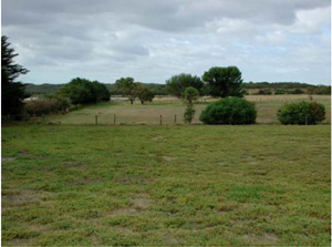
CLRA4 Landscape. Near level alluvial plains near St Leonards.
Soil Profile Morphology:
Surface Soil
| A1 | 0–15 cm | Dark grey (10YR4/1); fine sandy loam; weak medium sub-angular blocky structure; rough fabric; weak consistence dry; pH 5.5; wavy clear boundary to: | 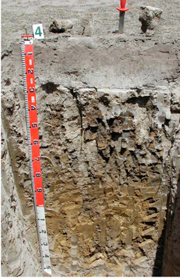 CLRA4 Profile. CLRA4 Profile. | |||
| A2 | 15–30 cm | Light brownish grey (10YR6/2), conspicuous bleach (10YR8/1 dry); heavy fine sandy loam; apedal massive structure; earthy fabric; very firm consistence dry; pH 6.0; smooth abrupt boundary to: | ||||
| Subsoil | ||||||
| B21 | 30–80 cm | Brown (10YR5/3) with many medium distinct orange grey and red (10YR5/6, 10YR4/1, 2.5YR5/6) mottles; light medium clay; strong coarse columnar, parting to strong medium angular blocky structure; smooth fabric; common prominent clay skin and other cutans; very strong consistence dry; few (6–60 mm) ferruginous soft concretions; pH 7.0; wavy gradual boundary to: | ||||
| B22 | 80–120 cm | Yellowish brown (2.5Y5/4); light medium clay; weak coarse columnar parting to medium and strong medium prismatic structure; smooth fabric; few distinct clay skin cutans; strong consistence dry; pH 8.5; wavy gradual boundary to: | ||||
| B23/B3 | 120–145+ cm | Light yellowish brown (2.5Y6/4) with few large yellow faint mottles; medium clay; weak coarse columnar, parting to medium and strong medium prismatic structure; smooth fabric; very few faint clay skin cutans; strong consistence dry; pH 8.5. | ||||
Soil Profile Characteristics:
Horizon | Sample Depth (cm) | pH (water) | pH (CaCl2) | EC 1:5 | NaCl % | Exchangeable Cations | |||
Ca | Mg | K | Na | ||||||
meq/100g | |||||||||
A1 | 0–15 | 5.2 | 4.6 | 0.12 | 2.7 | 1.2 | 0.57 | 0.51 | |
A2 | 15–30 | 5.7 | 5.1 | <0.05 | 0.58 | 0.31 | 0.1 | 0.16 | |
B21 | 30–80 | 7.4 | 6.4 | 0.29 | 0.04 | 3.7 | 10 | 0.3 | 4.9 |
B22 | 80–120 | 8.1 | 7.1 | 0.41 | 0.06 | 2.3 | 8.1 | 0.3 | 5.1 |
B23/B3 | 120–145+ | 8.1 | 7.2 | 0.61 | 0.11 | 3.4 | 12 | 0.4 | 8 |
Horizon | Sample Depth (cm) | Exchangeable Aluminium mg/kg | Exchangeable Acidity cmolc/kg | Field Capacity pF2.5 | Wilting Point pF4.2 | Coarse Sand (0.2- 2.0 mm) | Fine Sand (0.02- 0.2 mm) | Silt (0.002- 0.02 mm) | Clay (<0.002 mm) |
A1 | 0–15 | 12 | 9.1 | 23.4 | 5.9 | 10.6 | 62.4 | 14 | 7 |
A2 | 15–30 | <10 | 2 | 15.2 | 1.5 | 11.6 | 68.2 | 19 | 2.5 |
B21 | 30–80 | 37.3 | 17.2 | 7.4 | 46.4 | 8 | 34.5 | ||
B22 | 80–120 | 33.1 | 15.0 | 6.2 | 49.9 | 10 | 30.5 | ||
B23/B3 | 120–145+ | 43.3 | 27.8 |
Management Considerations:
- This soil has a strong texture contrast between the surface soil and the subsoil as well as sodic subsoils.
- It is important to maintain or improve the upper soil by increasing organic matter (particularly in the subsurface soil). The organic carbon content of the surface is 2% and the subsurface is 0.36%.
- Maintenance of a vegetative cover is important for soil stability particularly where the surface soil is light and susceptible to water and wind erosion.
- Root penetration of the subsoil may be difficult with the hardsetting nature of the soil, coarse structure and nutrient imbalance (alkalinity with high sodicity and some salinity).
- It would be advisable not to bring the very dispersive subsoil [Emerson class1] to the surface as it would promote surface sealing (hardsetting) as well as adverse nutrient affects.
Profile Described By: David Rees (December 2002).
Source: Robinson et al (2003) A land resource assessment of the Corangamite region. Department of Primary Industries, Centre for Land Protection Research Report No. 19
© State of Victoria (Agriculture Victoria) 1996 - .

This work, Victorian Resources Online, is licensed under a Creative Commons Attribution 4.0 licence. You are free to re-use the work under that licence, on the condition that you credit the State of Victoria (Agriculture Victoria) as author, indicate if changes were made and comply with the other licence terms.
The licence does not apply to ‘branding’ or some ‘images or photographs’ that may be owned by third parties. We ask you to seek prior approval to use images using the VRO feedback form. Access to higher quality images can also be provided on request.
This page was last updated on .