
Soil/Landform Unit 188
Landform Unit Description
Page top
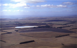 Sequence of swamps, lakes and sedimentary plains near Leslie Manor |
0.80% of CMA region This unit consists of near level plains in the Bookar and the Leslie Manor areas on the western shore of Lake Corangamite, between Camperdown and Lismore. As part of the Western Plains, the sedimentary plains are situated with stony rises to the north (Unit 112) and basaltic low hills to the south (Unit 111). The major occurrence of this unit is dissected by valleys of swamps and lunettes (Unit 201). Soils are alkaline (strongly sodic) brown and grey texture contrast soils (Sodosols). Restricted site drainage makes these soils susceptible to waterlogging, depending on surface soil depth. Structure decline may also be a concern, as are the strongly sodic subsoils. Land use is dominantly grazing with annual rainfall variations across the unit influencing intensity of grazing (some dairying) and some cropping. | 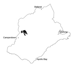 |
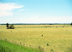 These heavy soils on level plains near Lake Terangpom have surface water removed by a number of drains leading to the lake | 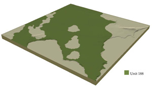 |
 | 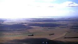 Plains east of Mount Myrtoon |
Component | 1 | 2 | 3 |
Proportion of soil-landform unit | 85% | 10% | 5% |
| CLIMATE Rainfall (mm) | Annual: 620 | ||
| Temperature (oC) | Minimum 8, Maximum 19 | ||
| Precipitation less than potential evapotranspiration | October–March | ||
| GEOLOGY Age and lithology | |||
| Geomorphology | |||
| LANDUSE | Uncleared: Water supply; nature conservation Cleared areas: Sheep and beef cattle grazing; cropping | ||
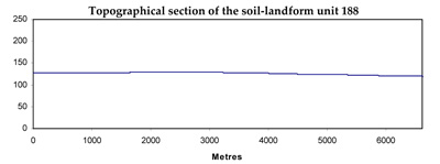
| TOPOGRAPHY Landscape | Level plains | ||
| Elevation range (m) | 113–147 | ||
| Local relief (m) | 1 | ||
| Drainage pattern | Centripetal | ||
| Drainage density (km/km2) | 1.3 | ||
| Landform | Plains | Drainage lines | |
| Landform element | Plain | Drainage depressions | Drainage lines |
| Slope and range (%) | 0 (0–1) | 0 (0–1) | 1 (0–2) |
| Slope shape | Linear | Concave | Concave |
| NATIVE VEGETATION Ecological Vegetation Class | Plains Grassland / Plains Grassy Woodland Mosaic (1.5%) | ||
| SOIL Parent material | Gravel, sand and silt | Gravel, sand, silt and clay | Gravel, sand, silt and clay |
| Description (Corangamite Soil Group) | Alkaline mottled brown, grey or yellow texture contrast soil (14) | Alkaline mottled brown, grey or yellow texture contrast soil (14) | |
| Soil type sites | |||
| Surface texture | Fine sandy loam | Fine sandy loam | Fine sandy loam |
| Permeability | Low to moderate | Very low | Very low |
| Depth (m) | <2 | > 2 | > 2 |
| LAND CHARACTERISTICS, POTENTIAL AND LIMITATIONS | Large texture contrast between surface and subsoil with contrast in water holding capacity, permeability and nutrient holding capacity. Strongly sodic subsoil, sometimes surface soil, hardsetting when dry, limited structure. Little relief; Imperfect to poor site drainage. | Large texture contrast between surface and subsoil with contrast in water holding capacity, permeability and nutrient holding capacity. Strongly sodic subsoil, sometimes surface soil, hardsetting when dry, limited structure. Very poor site drainage. | Large texture contrast between surface and subsoil with contrast in water holding capacity, permeability and nutrient holding capacity. Strongly sodic subsoil, sometimes surface soil, hardsetting when dry, limited structure. Poor to very poor site drainage. |
© State of Victoria (Agriculture Victoria) 1996 - .

This work, Victorian Resources Online, is licensed under a Creative Commons Attribution 4.0 licence. You are free to re-use the work under that licence, on the condition that you credit the State of Victoria (Agriculture Victoria) as author, indicate if changes were made and comply with the other licence terms.
The licence does not apply to ‘branding’ or some ‘images or photographs’ that may be owned by third parties. We ask you to seek prior approval to use images using the VRO feedback form. Access to higher quality images can also be provided on request.
This page was last updated on .