
Soil/Landform Unit 112
Landform Unit Description
Page top
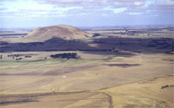 Stony rises surround the base of Mount Elephant at Derrinallum |
2.22% of CMA region The unit consists of an irregular surface of widespread basalt lava flows in which hummocks, depressions, ridges and blind channels have given rise to a completely confused topography. These stony rises occur along the Corangamite and Glenelg- Hopkins catchment boundary and have relief of less than 10 m. The stony rises are relatively recent basalt flows and have experienced little regolith and drainage development within the Western Plains. The rises are comprised of stony mounds that have shallow red and/or black loamy soils, numerous swamps with black cracking clays and gentle plains that are relatively rock-free with texture contrast soils. The only vegetation class of these plains is the Stony Rises Herb-rich Woodland. This unit is large and there are many equivalent areas within the Glenelg-Hopkins catchment. Other basaltic units and alluvial streams surround the stony rises. Land use is grazing (mainly sheep) with cropping on rock free plains and swamps. While the stony nature of soils is a major limitation, waterlogging is a productivity issue particularly on the former swamps due to their low relief and the impermeable nature of these soils. | 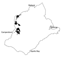 |
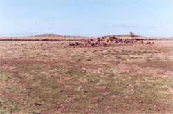 An example of the dense nature of stony rises | 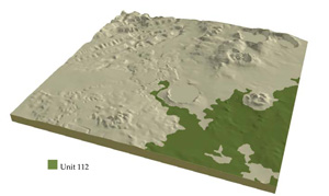 |
 | 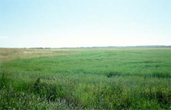 Relatively rock-free flats are highly productive, though waterlogging can be a concern |
Component | 1 | 2 | 3 |
Proportion of soil-landform unit | 60% | 30% | 10% |
| CLIMATE Rainfall (mm) | Annual: 660 | ||
| Temperature (oC) | Minimum 8, Maximum 19 | ||
| Precipitation less than potential evapotranspiration | October-March | ||
| GEOLOGY Age and lithology | |||
| Geomorphology | |||
| LANDUSE | Uncleared: Nature conservation Cleared: Sheep and beef cattle; cropping (marginal) | ||
| TOPOGRAPHY Landscape | Lava plain with hummocks, depressions, ridges and channels | ||
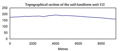
| Elevation range (m) | 113-302 | ||
| Local relief (m) | 30 | ||
| Drainage pattern | Deranged-centripetal | ||
| Drainage density (km/km2) | 0.7 | ||
| Landform | Rise | Plain | Playa plains |
| Landform element | Undulating stony rises | Undulating plain | Basin depression and playa |
| Slope and range (%) | 2 (1-4) | 1 (0-3) | 1 (0-2) |
| Slope shape | Convex | Straight | Concave |
| NATIVE VEGETATION Ecological Vegetation Class | Stony Rises Herb-rich Woodland (0.6%) | ||
| SOIL Parent material | In situ basalt | Basalt and colluvium | Basalt, colluvium and alluvium |
| Description (Corangamite Soil Group) | Alkaline mottled brown or yellow texture contrast soils (36) | Black cracking clays (31) | |
| Soil type sites | |||
| Surface texture | Clay loam light clay | Fine sandy clay loam | Light medium clay |
| Permeability | High | Low to moderate | Very low |
| Depth (m) | <0.7 | <2 | >2 |
| LAND CHARACTERISTICS, POTENTIAL AND LIMITATIONS | Loam (heavy) soils are shallow and friable. Low to moderate water holding capacity, moderate to high nutrient holding capacity. Some expansive clay soils. Often stony. Moderately rapid site drainage. | Texture contrast soil, low water holding capacity and moderate nutrient holding capacity in shallow surface and subsurface soils, higher in deep subsoil. Brown soils have moderate permeability, yellow (brown) soils have low to very low permeability. Strongly sodic subsoil, possible surface soil associated with poor drainage. Slow site drainage. | Uniform fine texture, expansive clays. High water holding capacity and nutrient holding capacity. Strongly sodic subsoil, possible surface soil associated with poor drainage. Some friable self-mulching surfaces wth high organic matter. Very slow site drainage. |
© State of Victoria (Agriculture Victoria) 1996 - .

This work, Victorian Resources Online, is licensed under a Creative Commons Attribution 4.0 licence. You are free to re-use the work under that licence, on the condition that you credit the State of Victoria (Agriculture Victoria) as author, indicate if changes were made and comply with the other licence terms.
The licence does not apply to ‘branding’ or some ‘images or photographs’ that may be owned by third parties. We ask you to seek prior approval to use images using the VRO feedback form. Access to higher quality images can also be provided on request.
This page was last updated on .