
Soil/Landform Unit 201
Landform Unit Description
Page top
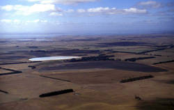 Swamps, flats and minor associated lunettes heading south-east towards Leslie Manor near Lake Corangamite |
0.08% of CMA region This unit consists of swamps, lakes and associated lunettes as part of an alluvial/aeolian complex on the north-west side of Lake Corangamite. This succession of lakes, swamps, plains and minor lunettes hosts a range of vegetation communities including Plains Grassland/Plains Grassy Woodland Mosaic, Grassy Woodland and Plains Sedgy Wetland. These small individual units are located within an alluvial area that drains directly into Lake Corangamite’s western shore. The unit has black gradational soils and some self-mulching grey cracking clays on the lunettes and flat plains. The soils are friable, strongly structured and productive, and generally deep with moderately rapid site drainage and no stone. The swamps have alkaline black or grey cracking clays. Rainfall is sufficient to influence grazing intensity (for dairying or beef/sheep production) and is slightly drier here than its associated unit to the south (Unit 150). Waterlogging and soil compaction are possible constraints in wet seasons for these soils. |  |
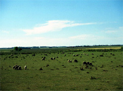 Flat plains of swamps and former swamps are heavily grazed over the drier seasons by beef cattle and sheep | 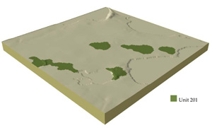 |
 | 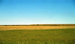 Long lunette bordering a vast plain near Lake Terangpom |
Component | 1 | 2 |
Proportion of soil-landform unit | 70% | 30% |
| CLIMATE Rainfall (mm) | Annual: 630 | |
| Temperature (oC) | Minimum 8, Maximum 19 | |
| Precipitation less than potential evapotranspiration | October–March | |
| GEOLOGY Age and lithology | Quaternary fluvial clay, silt and sand | |
| Geomorphology | ||
| LANDUSE | Uncleared areas: Water supply; nature conservation Cleared areas: Sheep and beef cattle grazing; dairy farming; water supply | |
| TOPOGRAPHY Landscape | Swamps and flats | |
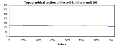
| Elevation range (m) | 120–140 | |
| Local relief (m) | 1–2 | |
| Drainage pattern | Centripetal–parallel | |
| Drainage density (km/km2) | 3.0 | |
| Landform | Plains and swamps | |
| Landform element | Flat plains | Swamps |
| Slope and range (%) | 1 (0–2) | 0 |
| Slope shape | Straight | Straight |
| NATIVE VEGETATION Ecological Vegetation Class | Plains Grassland / Plains Grassy Woodland Mosaic (1.8%), Grassy Woodland (1.3%), Plains Sedgy Wetland (1.2%) | |
| SOIL Parent material | Clay, silt and sand | Clay, silt and sand |
| Description (Corangamite Soil Group) | Mottled black texture contrast soils (32/33) and black or grey cracking clay soils (31) | Alkaline black or grey cracking clays (31) |
| Soil type sites | ||
| Surface texture | Clay loam to light clay | Light clay |
| Permeability | Low | Very low |
| Depth (m) | >2 | >2 |
| LAND CHARACTERISTICS, POTENTIAL AND LIMITATIONS | Friable, often self-mulching surface soils. Expansive clays in texture contrast subsoil as well as clay soils. Can be seasonally waterlogged with poor drainage. Deep soils with high water holding capacity. | Friable, often self-mulching surface soils. Expansive clays in texture contrast subsoil as well as clay soils. Can be seasonally waterlogged with poor drainage. Deep soils with high water holding capacity. |
© State of Victoria (Agriculture Victoria) 1996 - .

This work, Victorian Resources Online, is licensed under a Creative Commons Attribution 4.0 licence. You are free to re-use the work under that licence, on the condition that you credit the State of Victoria (Agriculture Victoria) as author, indicate if changes were made and comply with the other licence terms.
The licence does not apply to ‘branding’ or some ‘images or photographs’ that may be owned by third parties. We ask you to seek prior approval to use images using the VRO feedback form. Access to higher quality images can also be provided on request.
This page was last updated on .