
Soil/Landform Unit 184
Landform Unit Description
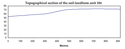
Page top
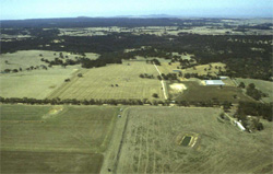 This unit has an abundance of remnant vegetation, in particular Plains Grassy Woodland near Inverleigh. Few units across the catchment have more than 50% vegetation coverage as this unit does |
0.10% of CMA region The sedimentary near-level plains at Teesdale are characterised by significant vegetation stands of Eucalyptus camaldulensis, with other species in forests and woodlands. These sediments comprise Neogene sands that have been deposited as part of a marine inundation in geologic time. This unit has a high level of remnant vegetation (approximately 60%) on plains that have relatively low inherent soil fertility levels. As part of the Western Plains, this unit has significant remnant native vegetation classes including Plains Grassy Woodland and Damp Sands Herb-rich Woodland. The dominant species of these woodlands include E. leucoxylon, Acacia pycnantha, E. melliodora, Casurina stricta, E. viminalis and E. camaldulensis. Land use is mainly nature conservation with grazing and minor cropping. The soils tend to be sandy mottled yellow, brown, red or black texture contrast soils with some uniform deep sands also. Main hazards to land use are overland flow causing sheet and rill erosion, and gully erosion. Soils are particularly limited for agricultural land use by their low nutrient status and poor water holding capacity. |  |
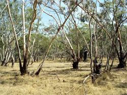 Plains Grassy Woodland vegetation north-west of Inverleigh | 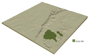 |
 |
Component | 1 | 2 | 3 | 4 | 5 | 6 | 7 |
Proportion of soil-landform unit | 30% | 9% | 12% | 10% | 4% | 28% | 7% |
| CLIMATE Rainfall (mm) | Annual 550 | ||||||
| Temperature (oC) | Minimum 9, Maximum 19 | ||||||
| Precipitation less than potential evapotranspiration | October–April | ||||||
| GEOLOGY Age and lithology | Holocene sand | Pleistocene basalt | Neogene unconsolidated sediments | Holocene alluvium | Sand ridge with ferricrete | Neogene unconsolidated sediments | |
| Geomorphology | |||||||
| LANDUSE | Uncleared: Nature conservation; water supply Cleared: Sheep and beef cattle grazing; cropping (cereal) | ||||||
| TOPOGRAPHY Landscape | Near level plains | ||||||
| Elevation range (m) | 54–135 | ||||||
| Local relief (m) | 7 | ||||||
| Drainage pattern | Dendritic | ||||||
| Drainage density (km/km2) | 2.3 | ||||||
| Landform | Sandy ridges, scarps and hummocks | level areas and rock outcrops | Lower lying areas between hummocks | Drainage line | Outcrop | Gently undulating plains | |
| Landform element | Upper slope | Mid slope | Mid slope | Lower slope | Mid slope | Upper plain | Lower plain |
| Slope and range (%) | 7 (2–15) | 1 (1–2) | 1 (1–3) | 1 (1–2) | 4 (3–8) | 3 (2–5) | 3 (1–5) |
| Slope shape | Convex | Convex | Straight | Straight - concave | Convex | Straight | Straight |
| NATIVE VEGETATION Structure | Plains Grassy Woodland (50.3%), Damp Sands Herb-rich Woodland (7.4%) | ||||||
| Dominant species | E. camaldulensis | E. camaldulensis | E. camaldulensis | E. camaldulensis | E. leucoxylon, Acacia pycnantha, E. melliodora, Casurina stricta, E. viminalis | E. leucoxylon, Acacia spp. | |
| SOIL Parent material | Unconsolidated sediments | In situ weathered basalt | Unconsolidated sediments | Unconsolidated sediments | Unconsolidated sediments | Unconsolidated clay, silt, sand and gravel | Unconsolidated clay, silt, sand and gravel |
| Description (Corangamite Soil Group) | Brown sand soils (8) | Mottled browm, grey or yellow texture contrast soils, coarse structure (36) | Mottled red texture contrast soils (13) | Uniform soils – variable (34) | Mottled brown sands and texture contrast soils (16) | ||
| Soil type sites | |||||||
| Surface texture | Loamy sand | Clay loam | Fine sandy loam | Silty clay loam (variable) | Fine sandy loam | Fine sandy loam | Sandy loam |
| Permeability | High | Moderate to low | High to moderate | High to moderate | Moderate | Moderate | Low |
| Depth (m) | 0.7–1.5 | 0.5–1.0 | 0.5–1.5 | 1.0–2.5 | 0.3–0.8 | 1.0–2.0 | 2 |
| LAND CHARACTERISTICS, POTENTIAL AND LIMITATIONS | Low nutrient holding capacity and highly permeable soils leads to leaching and nutrient decline. | Hardsetting surface soils leads to surface compaction and minor sheet erosion. Slowly permeable subsoils are subject to periodic waterlogging. | Some overland flow and minor sheet erosion occurs on these soil types. | Low lying areas lead to flooding, waterlogging and seasonally high watertables. Streambank undercutting and streambank erosion also commonly occur. | Some overland flow and moderate sheet erosion occurs on these soil types. | Hardsetting surface soils leads to surface compaction and minor sheet erosion. | Dispersive soils, overland flow, subsurface flow and moderate gully erosion are features of this soil type. |
© State of Victoria (Agriculture Victoria) 1996 - .

This work, Victorian Resources Online, is licensed under a Creative Commons Attribution 4.0 licence. You are free to re-use the work under that licence, on the condition that you credit the State of Victoria (Agriculture Victoria) as author, indicate if changes were made and comply with the other licence terms.
The licence does not apply to ‘branding’ or some ‘images or photographs’ that may be owned by third parties. We ask you to seek prior approval to use images using the VRO feedback form. Access to higher quality images can also be provided on request.
This page was last updated on .