
SW23
|
| SW23 | 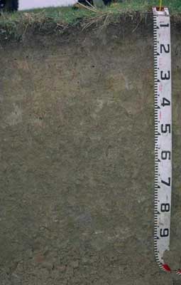 Acidic, Mesotrophic, Brown DERMOSOL | |
| Simpson | |||
| Undulating hills | |||
| Tertiary-Moorabool Viaduct Formation. | |||
| Lower slope | |||
Horizon | Depth (cm) | Description | ||
A1 | 0-10 | Dark brown (10YR3/3); fine sandy clay loam; weak consistency (moist); pH 5.6; abrupt boundary to: | ||
A2 | 10-25 | Light brownish grey (10YR6/2); rusty root channel mottling present; silty clay loam; weak coarse blocky structure; pH 5.4; clear boundary to: | ||
B1 | 25-40 | Light yellowish brown (2.5Y6/4) with reddish yellow (7.5YR6/6) mottles; heavy silty clay loam; weak to moderate coarse blocky structure; pH 5.2; clear boundary to: | ||
B21 | 40-70 | Brown (10YR5/3) with reddish yellow (7.5YR6/6) mottles; silty clay; moderate coarse blocky, parting to strong medium polyhedral structure; pH 5.0; clear boundary to: | ||
B22 | 70+ | Light brownish grey (10YR6/2) with brownish yellow (10YR6/6) mottles; light medium clay; weak very coarse prismatic, parting to strong coarse blocky and strong fine to medium polyhedral structure; pH 5.0. | ||
Analytical data
Site SW23 | Sample depth | pH | EC | NaCl | Ex Ca | Ex Mg | Ex K | Ex Na | Ex Al | Ex acidity | FC (-10kPa) | PWP (-150kPa) | KS | FS | Z | C | |
Horizon | cm | H2O | CaCl2 | dS/m | % | cmolc/kg | cmolc/kg | cmolc/kg | cmolc/kg | mg/kg | cmolc/kg | % | % | % | % | % | % |
A1 | 0-10 | 5.6 | 4.9 | 0.15 | N/R | 5.4 | 1.1 | 0.2 | 0.1 | N/R | N/R | 36.4 | 13 | 5 | 43 | 25 | 16 |
A2 | 10-25 | 5.4 | 4.6 | 0.1 | N/R | 1.9 | 0.8 | 0.3 | 0.05 | N/R | N/R | 25.6 | 8 | 2 | 50 | 30 | 16 |
B1 | 25-40 | 5.2 | 4.3 | 0.11 | N/R | 1.7 | 1.3 | 0.3 | 0.1 | N/R | N/R | 26.9 | 10.6 | 2 | 47 | 26 | 25 |
B21 | 40-70 | 5 | 4.2 | 0.13 | N/R | 1.8 | 1.8 | 0.3 | 0.2 | N/R | N/R | 28.5 | 13.1 | 2 | 42 | 26 | 30 |
B22 | 70+ | 5 | 4.2 | 0.15 | N/R | 2.2 | 3.9 | 0.3 | 0.3 | N/R | N/R | 30.5 | 16.5 | 1 | 35 | 21 | 42 |
© State of Victoria (Agriculture Victoria) 1996 - .

This work, Victorian Resources Online, is licensed under a Creative Commons Attribution 4.0 licence. You are free to re-use the work under that licence, on the condition that you credit the State of Victoria (Agriculture Victoria) as author, indicate if changes were made and comply with the other licence terms.
The licence does not apply to ‘branding’ or some ‘images or photographs’ that may be owned by third parties. We ask you to seek prior approval to use images using the VRO feedback form. Access to higher quality images can also be provided on request.
This page was last updated on .