
Soil and Landform Mapping
The information provided here has been developed from the project "A land resource assessment of the Wimmera region" by Robinson et al (2006). This project was undertaken by the former DPI's PIRVic Division for the Wimmera Catchment Management Authority. It utilised existing surveys (see Related Reports below), remote sensing information and additional field work to develop an updated 1:100 000 scale soil/landform mapping coverage across the region. A number of soil surveys have previously been completed in this region at varying scales and intensity. Details about these can be found in the Soil and Land Survey Directory on this website.
To view the information PDF requires the use of a PDF reader. This can be installed for free from the Adobe website (external link).
 | Summary (PDF 21KB) Preface (PDF 11KB) Acknowledgements (PDF 14KB) | 3. | Soil-landforms (PDF 621KB) 3.1 Concept and definitions 3.2 Map cretaion | |
| List of abbreviations (PDF 10KB) | 4. | Soils (PDF 930KB) 4.1 Wimmera Soil Groups | ||
1. | Introduction (PDF 224KB) 1.1 Objectives 1.2 Location of the study area 1.3 Links to other projects 1.4 Background | 5. | Land conservation and susceptibility (PDF 24KB) 5.1 Land susceptibility | |
2. | Geomorphology of the Wimmera (PDF 2.1MB) 2.1 Landscape evolution of the Wimmera region 2.2 Geomorphic framework for the Wimmera region 2.3 Terminology used for 3rd tier geomorphological units in this report | Appendix A - Criteria used in land degradation analysis (PDF 25KB) Appendix B - Mapsheet reliability (PDF 22KB) Appendix C - Map Labels (PDF 14KB) | ||
| References (PDF 25KB) | ||||
| A Land Resource Assessment of the Wimmera Region (PDF - 3.8 MB) A Land Resource Assessment of the Wimmera Region (DOC - 6.8 MB) | ||||
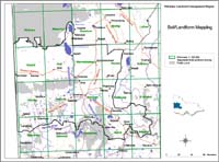 Wimmera Soil/Landform Mapping | Over 106 soil/landform units have been defined for the region. Each soil/landform described includes photographs of the general landscape as well as 3-D block diagrams and topographic section profiles. For each soil-landform appropriate soil sites are listed - that are considered to be good examples of soil types that can occur in these units. The map on this page enables you to click onto a 1:100 000 map sheet of interest and bring up the soil-landform map as well as a listing of soil-landform units, soil groups and geomorphic units that occur on each sheet. |
Access to spatial data
A spatial dataset of "A Land Resource Assessment of the Wimmera Region" (DOI 10.4226/92/58e729e8aea3e) is freely available through the DataVic website.
Related Reports
Regional Soil Survey Information
- Soils of the Lowan Region
- Soils of the Neuarpur Region
- soils of the Wimmera Irrigation Region
- Soils of the Eastern Wimmera
- Soils of the Vineyard Districts
- Soils of the Horsham Mapsheet No. 7324 - Report No. 57
- Soils of the Kalkee Plains - Report No. 53
Land Systems
© State of Victoria (Agriculture Victoria) 1996 - 2025.

This work, Victorian Resources Online, is licensed under a Creative Commons Attribution 4.0 licence. You are free to re-use the work under that licence, on the condition that you credit the State of Victoria (Agriculture Victoria) as author, indicate if changes were made and comply with the other licence terms.
The licence does not apply to ‘branding’ or some ‘images or photographs’ that may be owned by third parties. We ask you to seek prior approval to use images using the VRO feedback form. Access to higher quality images can also be provided on request.
This page was last updated on 25/01/2019.