
Land Use and Management
Back to: Victorian Meat and Wool Homepage
Historic Land Use
| Distribution of sheep 1944 This historic map shows the distribution of sheep in Victoria in 1944, including location of woollen mills, freezing works and meat dehydration factories. An inset map shows broad sheep husbandry types (e.g. mainly wool production, sheep and lamb fattening). | 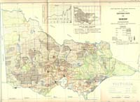 Distribution of Sheep (PDF - 373 KB) |
| Distribution of cattle (other than dairy cows) 1944 This historic map shows the distribution of cattle (other than dairy cows) in Victoria in 1944, including location of freezing works and meat dehydration factories. | 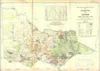 Distribution of Cattle (PDF - 346 KB) |
Related Links
The Victorian Sheep Industry Profile (2014) on the Agriculture Victoria website provides an overview of the location, structure and performance of Victoria's sheep industry.
The Victorian Beef Industry Profile (2014) on the Agriculture Victoria website provides an overview of the location, structure and performance of Victoria's beef industry.
Information on drought feeding and management of beef cattle and sheep is available on the Agriculture Victoria website.
An overview of Land management practice trends in Victoria’s grazing (beef cattle and sheep) industries is available on the Australian Government's Department of Agriculture and Water Resources website.
© State of Victoria (Agriculture Victoria) 1996 - .

This work, Victorian Resources Online, is licensed under a Creative Commons Attribution 4.0 licence. You are free to re-use the work under that licence, on the condition that you credit the State of Victoria (Agriculture Victoria) as author, indicate if changes were made and comply with the other licence terms.
The licence does not apply to ‘branding’ or some ‘images or photographs’ that may be owned by third parties. We ask you to seek prior approval to use images using the VRO feedback form. Access to higher quality images can also be provided on request.
This page was last updated on .