
How do landscapes affect our water resources?
To view the information PDF requires the use of a PDF reader. This can be installed for free from the Adobe website (external link).
Connecting landscapes to water resources impacts
The Victorian Government is committed to managing water resources to support a thriving economy, healthy environment and growing communities (Victorian Government White Paper: Securing Our Water Future Together), and DPI is supporting this commitment through Future Farming Strategy Action 4 'Strengthening land and water management'.
In order to manage our water resources there is a need to understand how climate change and land use change impact on Victoria's water resources. This project will investigate the role of surface and groundwater systems in the Goulburn and Ovens river catchments - in particular, how they respond to changing land use and climate conditions, the rivers' connection to landscapes and interactions between surface and groundwater systems.
Background
Water resources in Victoria are managed for a diverse range of uses including urban, industrial, agricultural (irrigation), recreation and the environment. Some of the key questions that Catchment Management Authorities as well as land and water managers are considering are:
- how will Victoria's water resources change as we move into a climate changed environment ?
- how can environmental releases be timed for maximum benefit to the catchment ?
- how do we understand the impacts of diverse land use and management practices on water resources ?
- how do large fires affect water quantity and quality of water generated at the catchment scale ?
- are current farming practices viable under predictions of climate change, and what does this mean for the management of water resources?
A range of tools including hydrological models are used to investigate these questions and inform the decision making process.
| Why is the water - landscape connection important? Streamflow is determined by climate, water use within the catchment as well as the pathways and rate of water movement to streams. These factors vary significantly across a catchment. For example, this sub-catchment of the Ovens River in NE Victoria (2970 km 2) has:
| 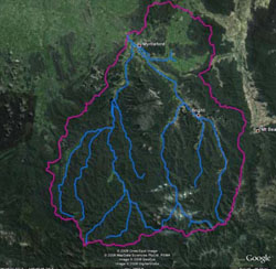 |
A key question for this research project is the extent to which incorporating this landscape complexity adds to our understanding and management of water resources under future climate and land use scenarios. | |
Overview
Many of the commonly used tools for understanding and managing water resources at the catchment scale consider the catchment as a series of linked stream nodes through which streamflow is routed (e.g. SimHyd). These models, which are driven by rainfall and potential evapotranspiration, generally give good predictions of historic and current conditions and represent a valuable tool for understanding and managing stream flow.
More complex models can also be used, which are more closely linked to biophysical processes and landscape variability. While these more complex models require more input data, they also generally give good predictions of historic and current streamflow.
While, most models can be calibrated to successfully describe historical stream gauge data, the ability of various models to investigate future climate and land use scenarios depends on the validity of model assumptions, calibration and sensitivity to future scenarios.
This project will explore the level of complexity and connection to landscape that is required within model tools to answer some of the key water management questions. While simple rainfall/runoff models may be suitable for some questions, others such as the effect of land management and land-use change will require more complex models.
The project will use a simple rainfall-runoff model, such as SimHyd, as a base case. The project will investigate the ability to describe current streamflow and the potential to use SimHyd to investigate streamflow under current and future land-use and climate change scenarios. The project will then progressively increase the complexity of the model used and the connection between landscape and streamflow represented by the model.
Using the most appropriate tool to inform water management and policy into the future is essential. While any modelling tool can give an answer and may increase our understanding of the effect of changing climate, land use change and natural events such as bushfires, it is essential that the inherent limitations of the modelling tools used are understood and the appropriate level of landscape connection is incorporated.
 | Key Contact Kirsten Barlow (02) 6030 4500 Kirsten.Barlow@dpi.vic.gov.au |
© State of Victoria (Agriculture Victoria) 1996 - 2025.

This work, Victorian Resources Online, is licensed under a Creative Commons Attribution 4.0 licence. You are free to re-use the work under that licence, on the condition that you credit the State of Victoria (Agriculture Victoria) as author, indicate if changes were made and comply with the other licence terms.
The licence does not apply to ‘branding’ or some ‘images or photographs’ that may be owned by third parties. We ask you to seek prior approval to use images using the VRO feedback form. Access to higher quality images can also be provided on request.
This page was last updated on 23/03/2020.