
Catchment Analysis Tool
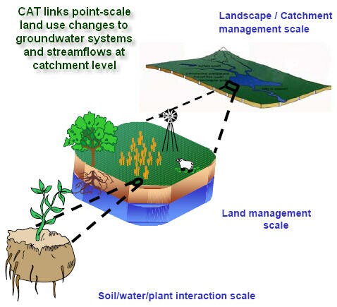
The Catchment Analysis Tool (CAT) provides a modelling framework at a catchment scale to assess farming and forestry impacts on streams and groundwater.
Information from exisiting models has been used to identify landscape, soil and plant interactions and predict water flow (surface and subsurface and deep drainage) for different plant systems.
A series of fact sheets have been developed outlining CAT and its capabilities.
| Fact Sheets |
The CAT technical reference manual details the formulations embedded in the Catchment Analysis Tool (CAT1D) farming system model. The CAT1D model comprises a suite of farming system models of varying complexity from a simple crop cover approach to complex phenological based pasture, crop and forest growth models which simulate soil/water/plant interactions on a daily timestep.
Technical Manual for the Catchment Analysis Tool
© State of Victoria (Agriculture Victoria) 1996 - 2025.

This work, Victorian Resources Online, is licensed under a Creative Commons Attribution 4.0 licence. You are free to re-use the work under that licence, on the condition that you credit the State of Victoria (Agriculture Victoria) as author, indicate if changes were made and comply with the other licence terms.
The licence does not apply to ‘branding’ or some ‘images or photographs’ that may be owned by third parties. We ask you to seek prior approval to use images using the VRO feedback form. Access to higher quality images can also be provided on request.
This page was last updated on 22/02/2021.