
Connecting Landscapes to Water Resources Impacts
|
The Victorian Government is committed to managing water resources to support a thriving economy, healthy environment and growing communities. To realise the Victorian Government commitment of maintaining our water resources there is a need to understand how climate change and land-use change impact on Victoria's water resources and associated environmental assets. The Ovens and Goulburn rivers contribute significantly to the water resources of the Murray-Darling Basin. These two rivers are similar in many ways in terms of their geomorphology, land-use, and vegetation communities, but the Ovens River is largely unregulated while the Goulburn is highly regulated. This project is a part of the eWater CRC 'Northern Vic Focus Catchments (Goulburn and Ovens)'project which is investigating how potential flow scenarios, based on land management and climate change, can affect the river and floodplain ecology of the Goulburn and Ovens Catchments. The project involves a range of industry partners including Department of Primary Industries (Victoria), Environment Protection Authority (Victoria), Goulburn-Broken Catchment Management Authority, North East Catchment Management Authority, Goulburn-Murray Water, and The University of Melbourne. The 'Northern Vic Focus Catchments (Goulburn and Ovens)' project will result in a better capacity to manage the balance between environmental and consumptive uses; more effective planning and management of environmental outcomes; and greater capacity for integrated surface and groundwater management. | 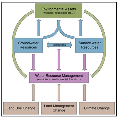 |
- Describe the hydrology of the Ovens river and unregulated catchments in the Goulburn river under historic climate and future climate scenarios - Northern Victorian Focus Catchments
- Investigate the importance of including landscape complexity in modelling water resources under current conditions and future climate and land-use scenarios - How do landscapes affect our water resources?
- Apply a classification framework for groundwater–stream interactions to increase our understanding of the relationships between groundwater and stream systems in the Ovens and Goulburn catchments - Groundwater - surface water interactions
- Communicate findings to government, policy, science and industry audiences - Publication List.
Government, policy makers, scientists and land managers are better informed on how different land use and climate scenarios impact on water flow and quality in upland catchments (Goulburn and Ovens Rivers). Enabling improved river and floodplain management by better understanding upland flow generation, groundwater interactions and the sensitivity of floodplain ecosystems to changes in surface water and groundwater fluxes.
 | The eWater CRC (external link) aims to provide tools to enable the efficient management of Australian Water Resources. |
Key Contact
Kirsten Barlow
(02) 6030 4500
kirsten.barlow@dpi.vic.gov.au
© State of Victoria (Agriculture Victoria) 1996 - 2025.

This work, Victorian Resources Online, is licensed under a Creative Commons Attribution 4.0 licence. You are free to re-use the work under that licence, on the condition that you credit the State of Victoria (Agriculture Victoria) as author, indicate if changes were made and comply with the other licence terms.
The licence does not apply to ‘branding’ or some ‘images or photographs’ that may be owned by third parties. We ask you to seek prior approval to use images using the VRO feedback form. Access to higher quality images can also be provided on request.
This page was last updated on 23/03/2020.