
Cranbourne
Cranbourne - Symbol: Cr
| The Cranbourne mapping unit occurs in the north-eastern part of the Mornington Peninsula Shire and is formed on early Pleistocene sands which occur as dunefields. Cranbourne sand is the main soil type and near Cranbourne it been extensively quarried and the surface soil used for topdressing of lawns and playing fields. The immediate subsoil is often used as packing sand and the deep subsoil used for bricklaying and concrete production. Cranbourne sand typically has a dark grey sand surface becoming light grey by about 300mm depth. Dark brown and yellow brown cemented sands (termed ‘coffee rock’) usually occur at about 1metre depth. Mottled light yellowish brown and light grey sands occur under the coffee rock, and mottled yellow-brown and light grey clays occur at greater depths, generally below 1metre. The surface soils typically strongly acidic with a pH around 4.5 to 5.0 and the subsoils around pH 4.5 to 5.5. The coffee rock layer may impede the downward movement of water in which case subsurface drainage may be required. These soils are referred to as Aeric Podosols using the Australian Soil Classification. This mapping unit is distinguished from the Cerberus mapping unit in that the Cranbourne dunefields are geologically older and the soils are more acidic. However, the boundary between the two has proved difficult to establish. These soils are inherently of low fertility and because they are sandy they retain little water. However, with irrigation, fertilizers and additional organic matter they become highly productive. The main attraction of these soils is that they can be cultivated over most of the year and often two or more crops may be grown annually. The remnant vegetation is described as heathy woodland. Most of the land is cleared and is used for market gardens, but there is some remnant vegetation within the RAN establishment at Cerberus. | 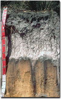 Aeric Podosol near Pearcedale |
Cranbourne, shallow - Symbol: Cr, sh
In this mapping unit the sands are similar to the Cranbourne unit but differ in that the depth to the clay subsoil is generally less than 1metre. Just above the clay, there is a layer of variably cemented sand (‘coffee rock’) or a layer of ironstone gravel concretions.
As with Cranbourne sand, these soils have a low inherent fertility and because they are sandy they retain little water. With irrigation, fertilizers and additional organic matter, however, they become highly productive.
Although they can be cultivated over most of the year, the coffee rock layer and clay layer impedes the free downward movement of water. Subsurface drainage would be normally be required for vegetable production over the wetter months.

© State of Victoria (Agriculture Victoria) 1996 - 2025.

This work, Victorian Resources Online, is licensed under a Creative Commons Attribution 4.0 licence. You are free to re-use the work under that licence, on the condition that you credit the State of Victoria (Agriculture Victoria) as author, indicate if changes were made and comply with the other licence terms.
The licence does not apply to ‘branding’ or some ‘images or photographs’ that may be owned by third parties. We ask you to seek prior approval to use images using the VRO feedback form. Access to higher quality images can also be provided on request.
This page was last updated on 23/11/2018.