
Soils/Landforms of the Mornington Peninsula
Geology and Geomorphology | References
This soil/landform survey was completed by Ian Sargeant during 2002/03 as part of a study undertaken by the former Department of Primary Industries for the Mornington Peninsula Shire.
The aims of this survey were to describe the major soils and landforms of the Mornington Peninsula and map them at a scale of 1:100 000. The survey is based on the concept of “soil/landscapes” which are areas of land that “have recognisable and specifiable topographies and soils, that are capable of presentation on maps, and can be described by concise statements “(Northcote, 1978). However, rather than using the term “soil landscapes” the term “mapping units” is used as it is more flexible and has a less precise definition.
The mapping units are described in terms of geology and landform, and the range of soils within each mapping unit is described. The boundaries between the mapping units were drawn onto aerial photographs (approximated scale 1:50 000) and then transferred to topographical maps at scale of 1:25 000 for digitising. The map should be used at a scale of 1:100 000 and should not be extrapolated to a larger (i.e. more detailed) scale. | 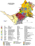 Soil/Landform Mapping Mornington Peninsula Shire (PDF 1 MB) To view the information PDF requires the use of a PDF reader. This can be installed for free from the Adobe website (external link). |
About 300 sites were examined, mostly exposed by soil auger and including a number of roadside cuttings. The descriptions of most of the auger sites were obtained from an earlier soil survey (Sargeant, 1974). The summer of 2002/3 was particularly dry, resulting in soils which were difficult to almost impossible to auger given the time and resourcing constraints imposed on the soil survey. An additional difficulty was access to properties, so most of the sites examined were on roadside reserves. Geological maps (scale 1:63 360), together with aerial photo-interpretation, were also used to help establish the soil boundaries.

© State of Victoria (Agriculture Victoria) 1996 - 2025.

This work, Victorian Resources Online, is licensed under a Creative Commons Attribution 4.0 licence. You are free to re-use the work under that licence, on the condition that you credit the State of Victoria (Agriculture Victoria) as author, indicate if changes were made and comply with the other licence terms.
The licence does not apply to ‘branding’ or some ‘images or photographs’ that may be owned by third parties. We ask you to seek prior approval to use images using the VRO feedback form. Access to higher quality images can also be provided on request.
This page was last updated on 23/11/2018.