
Site 41 Lake Elizabeth
Description
Located west of Kerang, this permanently saline wetland is surrounded by a lunette with areas of Black Box on the higher ground and salt indicator species occurring around the high water mark. This wetland has been changed since European settlement due to clearing of deep- rooting species, irrigation practices and a reduction in ‘flushing’ events. The adjacent land use includes cropping.
Vegetation Description and Composition Sites on this saline wetland support Woodland dominated by Eucalyptus largiflorens (Black Box) on the higher ground, with a herbaceous layer dominated by members of the Chenopodiaceae and Poaceae Families. The site has a high proportion of introduced species in the herbaceous layer (almost 70% of species present in 2001/2002, but now reduced to 55%) including several pasture weeds. Salt indicator species are in large numbers and continue to make up at times over 50% of species present (eight species noted in Quadrat A and five in Quadrat B.) Abundance of introduced species has been reduced, while the drought tolerant native species are more stable in numbers. Overall there has been a minimal change in the vegetation survey results, when dry seasonal conditions are considered, compared to previous vegetation data. Tree health remains in decline. | 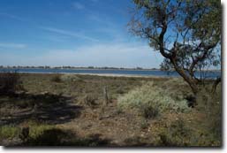 Lake Elizabeth |
Water Quality
Lake Elizabeth has water all year round and is fed mainly by channel outfall as well as from a couple surface drains. Salinity levels measured in the lake are around 40 000 to 50 000 EC. Lake Elizabeth is believed to have a relationship with the surrounding groundwater and is kept above a certain height to reduce groundwater intrusion into the lake system, and to prevent the lake from becoming too salty as it provides a habitat for the rare Murray Hardyhead fish, which only can withstand salinities upto 50 000 EC.
Groundwater and Salinity
The water tables around the lake have come very close to the surface (within 1.5 metres), but due to the drier years have fallen to below 2.5 metres. Recent groundwater salinity levels are similar to levels measured in the lake (i.e. around 50 000 EC).
Threats to the site continue to be:
- Invasion by Juncus acutus (Spiny Rush) and Tamarix ramosissima (Athel Pine)
- Grazing by rabbits and hares
Monitoring Survey Dates
December 1997, December 1998, December 1999, December 2000, November 2001, December 2002.
© State of Victoria (Agriculture Victoria) 1996 - 2025.

This work, Victorian Resources Online, is licensed under a Creative Commons Attribution 4.0 licence. You are free to re-use the work under that licence, on the condition that you credit the State of Victoria (Agriculture Victoria) as author, indicate if changes were made and comply with the other licence terms.
The licence does not apply to ‘branding’ or some ‘images or photographs’ that may be owned by third parties. We ask you to seek prior approval to use images using the VRO feedback form. Access to higher quality images can also be provided on request.
This page was last updated on 23/03/2020.