
Site 40 Lake Murphy
Description
Located to the south-west of Kerang, Lake Murphy is fed mainly by channel water and surface drains and becomes divided into two when water levels are low. A large number of water birds inhabit the lake when water is present. The landuse adjacent to the reserve includes grazing and cropping.
Vegetation Description and Composition Lake Murphy is surrounded by Open Woodland dominated by Eucalyptus largiflorens (Black Box) with a herbaceous layer dominated by members of the Chenopodiaceae and Poaceae Families. The site has a high proportion of introduced species in the herbaceous layer, consistently over 50% each year – mainly introduced species of the Asteraceae Family. The total number of species present has been reduced, and eight salt indicator species comprise over 50% of species present. Lake Murphy was drying out at the time of the surveys. Tree health continues to decline. | 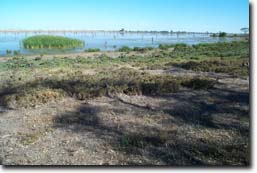 Lake Murphy |
Water Quality
Lake Murphy slowly becomes saline as water levels decline, reaching a salinity of around 20 000 EC just before completely drying up. But at full supply level water quality is reasonably fresh, no more than 1 000 EC.
Groundwater and Salinity
The water table around the lake is fairly shallow, coming within 2.2 metres of the surface, and salinity is above 50 000 EC.
Threats to the site continue to be:
- grazing by cattle and rabbits
- runoff of soil and nutrients from adjacent excessively overgrazed paddocks.
- invasion of Tamarix ramosissima (Athel Pine) - a Weed of National Significance (WONS) (NWSEC 1999) and Juncus acutus (Spiny Rush).
- possible inappropriate water regime (dried up in December 1998; filled again in 1999 from channel water; dry late 2000; filled in 2001 and again in late 2002).
Monitoring Survey Dates
December 1997, December 1998, December 1999, December 2000, November 2001, December 2002.
© State of Victoria (Agriculture Victoria) 1996 - 2025.

This work, Victorian Resources Online, is licensed under a Creative Commons Attribution 4.0 licence. You are free to re-use the work under that licence, on the condition that you credit the State of Victoria (Agriculture Victoria) as author, indicate if changes were made and comply with the other licence terms.
The licence does not apply to ‘branding’ or some ‘images or photographs’ that may be owned by third parties. We ask you to seek prior approval to use images using the VRO feedback form. Access to higher quality images can also be provided on request.
This page was last updated on 23/03/2020.