
Site 38 Great Spectacle Lake
Description
This Wetland has been dry since early 1998. It is part of a series of lakes that are fed through the Wandella Creek system. When Lake Meran reaches full supply level it flows through two smaller lakes before it reaches Great Spectacle Lake. The lake is surrounded by thick ring of Black Box around the edge above the high water mark. The adjacent land uses include cropping and grazing.
Vegetation Description and Composition This dry wetland is surrounded by Open Woodland dominated by Eucalyptus largiflorens (Black Box), with Open-Sedgeland occurring near the high water line (dominated by Cyperus and Juncus spp). Previously over 70% of the species present were introduced and almost 20% of the species present were salt indicator species. This has substantially changed. The number of species present has declined from over twenty species in both quadrats to seventeen in one quadrat and five in the other. Tree health appears to have remained in decline. The general appearance of the trees is that of being under continued stress. There has been a drastic change in vegetation survey results compared with previous vegetation data. The area is under extreme grazing pressure and the continued dry seasonal conditions account for the decline in species. Channel seepage is promoting the growth of Juncus acutus (Spiny Rush). Quadrat A has been excessively over grazed for several months and the abundance of plant species has been minimal. The understorey is almost completely absent. | 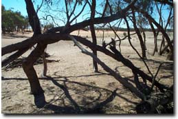 Great Spectacle Lake |
Water Quality
Water quality in the lake when full is generally fresh, reaching a salinity of 6 000 EC during it's drying phase.
Groundwater and Salinity
Groundwater in this area is deep - around >5.0 metres depth, with a salinity up to 30 000 EC.
Threats to the site continue to be:
- excessive grazing by sheep, cattle and rabbits eliminating any regeneration and promoting erosion.
- possible inappropriate water regime and channel seepage.
- rising salinity levels.
Monitoring Survey Dates
December 1997, November 1998, December 1999, February 2001, January 2002, December 2002.
© State of Victoria (Agriculture Victoria) 1996 - 2025.

This work, Victorian Resources Online, is licensed under a Creative Commons Attribution 4.0 licence. You are free to re-use the work under that licence, on the condition that you credit the State of Victoria (Agriculture Victoria) as author, indicate if changes were made and comply with the other licence terms.
The licence does not apply to ‘branding’ or some ‘images or photographs’ that may be owned by third parties. We ask you to seek prior approval to use images using the VRO feedback form. Access to higher quality images can also be provided on request.
This page was last updated on 23/03/2020.