
Site 34 Wandella Forest
Description
Located west of Kerang, this Black Box Woodland is part of the Wandella Creek system and can be subject to flooding at certain times. The adjacent land uses include grazing and cropping.
Vegetation Description and Composition This site is Woodland dominated by Eucalyptus largiflorens (Black Box). The understorey is predominantly Muehlenbeckia florullenta (Tangled Lignum) and Eragrostis infecunda (Cane Grass). The site has had a high proportion of introduced species recorded in the herbaceous layer (greater than 30% of species present) including many pasture weeds and four salt indicator species. The vegetation data of 2002/2003 indicates considerable change in the vegetation survey results compared with previous surveys. Only half the species are now present, due mainly to the continued dry seasonal conditions and grazing by rabbits and kangaroos. There has been an increase in large dry bare soil areas, which may influence weed spread in the future. Tree health appears to be in slight decline. The general appearance of the trees is one of being under continued stress. Kangaroos and rabbits have grazed all the previous new shoots of Tangled Lignum. | 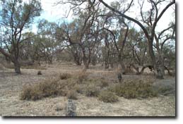 Wandella Forest |
Groundwater and Salinity
Depth to groundwater in and around Wandella Forest ranges from 2 metres to 4 metres, and salinity averages around 50 000 EC.
Threats to the site continue to he
- weed invasion, mainly pasture weeds.
- potential rising groundwater leading to a decrease in tree health.
- motorbikes being ridden through the site.
Monitoring Survey Dates
December 1997, December 1998, December 1999, December 2000, November 2001, December 2002.
© State of Victoria (Agriculture Victoria) 1996 - 2025.

This work, Victorian Resources Online, is licensed under a Creative Commons Attribution 4.0 licence. You are free to re-use the work under that licence, on the condition that you credit the State of Victoria (Agriculture Victoria) as author, indicate if changes were made and comply with the other licence terms.
The licence does not apply to ‘branding’ or some ‘images or photographs’ that may be owned by third parties. We ask you to seek prior approval to use images using the VRO feedback form. Access to higher quality images can also be provided on request.
This page was last updated on 23/03/2020.