
Site 32 Leaghur State Park
Description
This large Woodland, of predominantly Black Box, is situated on the Wandella Creek system between Kerang and Boort. It abuts Lake Meran and is occasionally flooded. Adjacent land uses include grazing and cropping.
Vegetation Description and Composition Woodland dominated by Eucalyptus largiflorens (Black Box). The understorey consists predominantly of members of the Chenopodiaceae and Poaceae Families. In 1997 the sites had over 50% of introduced species present including many pasture weeds in the herbaceous layer. Over the past three years this has reduced to zero. There are now three salt indicator species, compared to two in 1997 - Atriplex semibaccata, (Berry Saltbush), Enchylaena tomentosa, (Ruby Saltbush) and Chloris truncata, (Windmill Grass). Tree health appears to be in slight decline, with the general appearance of the trees being one of continued stress, most likely the result of insect attack and continued dry seasonal conditions. Grazing pressure appears less than in previous years. There has also been a major change in the vegetation survey results when compared with 1997 vegetation data. About 70% more species were present in recent years, most of these being native species. However, this had altered in late 2002, as there were no introduced species present, as a result of the continued dry seasonal conditions. These conditions also resulted in large areas of bare ground having developed. | 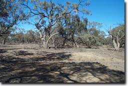 Leaghur State Park |
Threats to the site continue to be:
- weed invasion, particularly Juncus acutus (Spiny Rush) which is scattered throughout the Park.
- possible inappropriate water regime.
- regeneration being severely grazed by kangaroos, deer and rabbits.
Monitoring Survey Dates
December 1997, November 1998, December 1999, February 2001, January 2002, December 2002.
© State of Victoria (Agriculture Victoria) 1996 - 2025.

This work, Victorian Resources Online, is licensed under a Creative Commons Attribution 4.0 licence. You are free to re-use the work under that licence, on the condition that you credit the State of Victoria (Agriculture Victoria) as author, indicate if changes were made and comply with the other licence terms.
The licence does not apply to ‘branding’ or some ‘images or photographs’ that may be owned by third parties. We ask you to seek prior approval to use images using the VRO feedback form. Access to higher quality images can also be provided on request.
This page was last updated on 23/03/2020.