
Site 27 McDonalds Swamp
Description
Located to the northeast of Kerang, this is a freshwater Marsh is now fed by irrigation water and has water released into it annually. It provides a habitat for a number of birds when water is present. The adjacent land uses include cropping and cattle grazing.
Vegetation Description and Composition This Wildlife Reserve is a deep freshwater Marsh. The drier section is dominated by members of the Cyperaceae Family, including Baumea spp. (Twig-sedge), Eleocharis plana (Flat Spike-sedge), and Schoenoplectus validus (River Club-sedge), as well as the introduced grass Paspalum distichum (Water Couch). There is some remnant overstorey of Eucalyptus camaldulensis (Red Gum). The flooded section is dominated by Azolla filiculoides (Pacific Azolla), Typha orientalis (Cumbungi), Schoenus validus (River Club-sedge) and Myriophyllum spp. Greater than 50% of species present are now introduced species and their abundance has fluctuated over the past six years. There are now two salt indicator species present. Tree health is in decline and the general appearance of the trees is one of being under stress and in poor condition in the McDonald Swamp South quadrat. The trees in McDonald Swamp North quadrat appear healthy but have been planted and are not indigenous to the site. Eleocharisplana (Flat Spike-sedge) which is listed as "vulnerable" is still present. Tree regeneration is minimal due to continued loss of seedlings through grazing by cattle. There has been minimal change in vegetation survey results, if the seasonally dry conditions are considered when comparing previous vegetation data. | 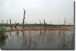 McDonalds Swamp |
Water Quality
McDonalds Swamp is a very fresh marsh which never rises much above 2 000 EC. Potential problems could be an increase in nutrients resulting from surrounding land uses.
Groundwater and Salinity
The watertables around this swamp are within 1.5 metres of the surface at times, and salinity can increase to 50 000 EC.
Threats to the site continue to be:
- rising groundwater and increasing waterlogging and salinity levels.
- nutrient increase
- pugging due to cattle grazing when wet.
- grazing of regeneration by cattle.
Monitoring Survey Dates
January 1998, October 1998, December 1999, February 2001, December 2001, December 2002.
© State of Victoria (Agriculture Victoria) 1996 - 2025.

This work, Victorian Resources Online, is licensed under a Creative Commons Attribution 4.0 licence. You are free to re-use the work under that licence, on the condition that you credit the State of Victoria (Agriculture Victoria) as author, indicate if changes were made and comply with the other licence terms.
The licence does not apply to ‘branding’ or some ‘images or photographs’ that may be owned by third parties. We ask you to seek prior approval to use images using the VRO feedback form. Access to higher quality images can also be provided on request.
This page was last updated on 23/03/2020.