
Site 22 Runnymede Recreation Reserve
Site appears to be in a stable environmental condition.
Description
This site is located at a popular traveller’s rest stop on the Northern Highway close to Elmore with the Campaspe River flowing close by. It is located on the riverine plain at an elevation of 132 metres. Platypus have been sighted feeding adjacent to the vegetation site. Parks Victoria manage and maintain the area and recently removed the septic system toilet block which had created problems through excessive nutrients in run-off and local weed invasion. Extensive landscaping work has been done in the carpark area and many new trees and shrubs have been established.
| Vegetation description and composition The EVC represented is Riparian Woodland listed as endangered in the Riverina Bioregion. The overstorey contains large mature Eucalyptus camaldulensis (Red Gum) trees with an understorey of Sedges, Common Tussock grass and introduced grass species. During 2000 the site was flooded to a depth of approximately two metres which deposited large amounts of debris across the vegetation quadrat. However, the site has remained dry ever since. The only salt indicator species Lolium spp. (Rye Grass) remains present. It is questionable whether this indicates saline conditions at the site for there are no other salt indicator species present and rye grass is a common weed. | 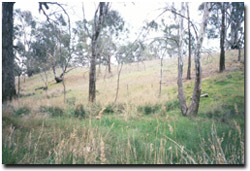 Runnymede Recreation Reserve in spring 2002 |
Juncus psammophilus (Sand Rush) is still the only vrot species present at the site.
Tree Health
Four trees are monitored for tree canopy health using a 20-point system assessing canopy size and density, number of dead branches and extent of epicormic growth. Leaf damage by insects could not be assessed because the trees at this site are extremely tall (branches >5 m) and samples could not be collected with pole pruners. Tree health recorded at the site is generally quite high, except for one tree that has a reduced canopy density and a large number of dead branches. During 2002 many trees at this site have shed their lower branches in response to dry conditions. This has also been a factor in reducing tree health scores.
Groundwater and salinity
Groundwater readings taken in 2002 demonstrated an average water table depth of 7m below natural surface and a salinity reading of just over 1 000 EC (i.e. relatively fresh water). Groundwater is very responsive to river volume and rises and falls in a similar pattern to the surface water flows in the Campaspe River.
Birds
Bird species present at the time of the vegetation and tree health surveys were :-
Australian Wood Duck, Brown Treecreeper, Crested Pigeon, Crimson Rosella, Galah, Kookaburra, Little Raven, Magpie, Masked Lapwing, Musk Lorikeet, Noisy Miner, Peaceful Dove, Clamorous Reed Warbler, Sacred Kingfisher, Spotted Pardalote, Striated Pardalote, Thornbill spp, Welcome Swallow, White-plumed Honeyeater, White-browed Woodswallow, White Winged Chough and Willie Wagtail.
Threats to the site include:
- weed invasion particularly Phalaris spp. (Canary grass) and Oxalis pes-caprae (Soursob).
© State of Victoria (Agriculture Victoria) 1996 - 2025.

This work, Victorian Resources Online, is licensed under a Creative Commons Attribution 4.0 licence. You are free to re-use the work under that licence, on the condition that you credit the State of Victoria (Agriculture Victoria) as author, indicate if changes were made and comply with the other licence terms.
The licence does not apply to ‘branding’ or some ‘images or photographs’ that may be owned by third parties. We ask you to seek prior approval to use images using the VRO feedback form. Access to higher quality images can also be provided on request.
This page was last updated on 23/03/2020.