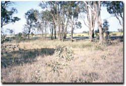
Site 20 Bendigo-Echuca railway road reserve, Goornong
Site appears to be in a stable environmental condition
Description
The area is located on the Northern Riverine Plain and is at an elevation of 154 metres. This road reserve has the Bendigo-Echuca railway line and the Midland Highway forming two of its site boundaries. Being a very narrow linear strip, the reserve is subject to constant weed invasion. However this site was selected for monitoring because it contains the endangered Plains Grassy Woodland EVC, and tree health is likely to show early signs of decline if water tables were to rise significantly in the area.
Vegetation Description and Composition The Plains Grassy woodland vegetation at the site is dominated by a scattered Eucalyptus microcarpa (Grey Box) overstorey with a native grassland understorey dominated by Themeda triandra (Kangaroo grass) and seasonal native herbs. Up to 2001 there had been a steady annual increase of approximately 10% in the total number of species present when compared to previous vegetation data. During 2002 there has been considerable change from previous vegetation data. The overall biomass has reduced and the percentage of introduced species has dropped to about 50%. In particular the clovers and medics, introduced members of the Fabaceae Family, were not present and native Chenopods (saltbushes) have started to appear. This is as a result of the long dry period the site has experienced. |  The Midland Highway forms one of the site boundaries (background) |
The two vrot species Eryngium plantagineum (Long Eryngium) and Maireana humillima (Dwarf Bluebush) are still present at the site.
Tree Health
Four trees are monitored for tree canopy health using a 20-point system assessing canopy size and density, number of dead branches and extent of epicormic growth. Leaf damage by insects is also assessed. Tree health at this site is very high with minor fluctuations in scores between years. Leaf damage by insects is also minimal.
Groundwater and Salinity
Two bores are located at the site, one is dry and the other had an average depth to groundwater of 13 m during 2001/2002 and showed a strong linear rising trend with some response to seasonal weather variation. The average rise has been 10-15 cm per year since 1996, regardless of the dry seasonal conditions. If the rising trend continues at this rate, high water tables will adversely affect the vegetation at the site in 30-50 years time. Groundwater salinity was >6 000 EC in 2002 (i.e. very saline water).
Birds
Bird species present at the time of the vegetation and tree health surveys were :-
Crimson Rosella, Galah, Magpie, Striated Pardalote and White-plumed Honeyeater.
Threats to the site include
- Continued weed invasion from road and rail in particular, Genista monspessulana (Cape Broom) and Echium plantagineum (Paterson’s Curse).
- Grazing by hares.
- Dumping of waste and rubbish in particular used vehicle oil.
- Disturbance due to road works along highway (e.g. gravel dumping and turning heavy vehicles).


