
Site 19 Yankee Creek
Site appears to be in environmental decline from weed invasion.
Description
This site is located adjacent to the Midland Highway on a narrow alluvial plain from the Yankee Creek at an elevation of 168 metres. The site is inundated on a regular basis and it is likely that the area has a history of light grazing. Previous soil disturbance and increased nutrient concentrations in the sediments as a consequence of flooding could be the reasons why more than half the species at the site are introduced.
Vegetation Description and Composition This site contains Creekline Grassy Woodland EVC, endangered within the Goldfields Bioregion. Species present include Eucalyptus camaldulensis River Red Gum) and an understorey of Carex appressa (Tall Sedge), Juncus psammophilus (Sand Rush) and Eleocharis acuta (Common Spike Sedge). The only salt indicator species Lolium spp. (Rye Grass) was recorded. It is questionable whether the presence of this species indicates saline conditions as it is a common weed and no other salt indicator species have ever been recorded at the site. Substantial clearing under the powerlines by Powercor occurred in 2000. The cutting to ground level of several Eucalyptus melliodora (Yellow Box) outside the quadrat and Eucalyptus camaldulensis (Red Gum) within the quadrat resulted in the site becoming less shaded and therefore drier. | 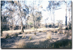 Yankee Creek Road Reserve. The Midland Highway is in the background |
During 2001 substantial coppice regrowth had developed on the lopped eucalypts, this has recently been removed. Drier conditions at the site may pose a threat to the health of Juncus psammophilus (Sand Rush), the only vrot species present within the site.
Previous surveys have been conducted after substantial rains and flooding of the site. Flood debris deposited during these events remains scattered across the vegetation quadrat. However, at the time of the 2002 vegetation survey, the site had been dry for almost two years.
There have been minimal changes to the vegetation composition at the site as a result of the dry conditions from the last couple of seasons. Native grasses Danthonia Spp. (Wallaby Grass) and Stipa Spp. (Spear Grass) were present in the 2002 survey and introduced species comprise over 60% of the species present.
Tree Health
Four trees are monitored for tree canopy health using a 20-point system assessing canopy size and density, number of dead branches and extent of epicormic growth. Leaf damage by insects is also assessed. All trees have experienced a slight decline in health in 2002 due to reduced canopy density in response to drought. Two of the trees had also suffered extensive leaf damage from lerps and leaf skeletoniser caterpillars.
Groundwater and salinity
One bore is located on the opposite side of the Midland Highway from the site and has shown a downward trend in water table depth due to dry seasonal conditions. In 2002 the average depth of the watertable was >7 m below natural surface and the salinity reading was almost 15 000 EC (i.e. water too saline for any agricultural purpose).
Birds
Bird species present at the time of the vegetation and tree health surveys were :-
Australian Raven, Black-faced Cuckoo-shrike, Crested Pigeon, Galah, Grey Shrike-thrush, Kookaburra, Magpie, Musk Lorikeet, Red-rumped Parrot, Spotted Pardalote, Striated Pardalote, Welcome Swallow, White-plumed Honeyeater and Willie Wagtail.
Threats to the site include:
- removal of overstorey resulting in drier site and possible reduction or loss of Juncus psammophilus Sand Rush, the only vrot species present within the site.
- weed invasion particularly Watsonia spp. and Phalaris spp.
- grazing by rabbits.
- St. John’s Wort present 50 m south of site on the roadside reserve.
- continued soil disturbance.
© State of Victoria (Agriculture Victoria) 1996 - 2025.

This work, Victorian Resources Online, is licensed under a Creative Commons Attribution 4.0 licence. You are free to re-use the work under that licence, on the condition that you credit the State of Victoria (Agriculture Victoria) as author, indicate if changes were made and comply with the other licence terms.
The licence does not apply to ‘branding’ or some ‘images or photographs’ that may be owned by third parties. We ask you to seek prior approval to use images using the VRO feedback form. Access to higher quality images can also be provided on request.
This page was last updated on 23/03/2020.