
Site 16 Elmore-Mitiamo Roadside Reserve
The site appears to be in environmental decline
Description
This road reserve is located on the northern riverine plain at an elevation of 99 metres. The area is treeless and is periodically grazed as evidence of stock pugging and droppings have been observed. It is possible that this site is at risk from rising water tables caused by sub-lateral flow from the adjacent Pyramid Hill Irrigation area.
Vegetation Description and Composition The vegetation type at this site is the endangered Plains Grassland EVC, which has an indicative place listing on the Register of the National Estate and is therefore recognised as Nationally significant. The Loddon Shire completed a roadside survey and erected significant roadside vegetation signs some years ago. The area is dominated by a mixture of native tussock grasses including: Danthonia spp. (Wallaby Grass), Enteropogon acicularis (Curly Windmill Grass), Stipa spp. (Spear grass) and Chloris truncata (Windmill Grass) with Calocephalus citreus (Lemon Beauty-heads), Pycnosorus globosus (Drumsticks), and Maireana spp. (Bluebush), Eryngium plantagineum (Long Eryngium) vrot. The number of introduced species has been reduced by continued dry conditions by more than 20%, particularly from members of the Asteraceae, Fabaceae and Poaceae Families. Avena spp. (Wild Oats) and Lolium spp. (Rye Grass) were not recorded in 2002. | 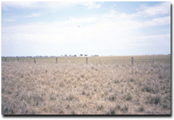 Elmore-Mitiamo Roadside Reserve in spring 2002 |
The continued dry seasons have maintained native grass growth, in particular Curly Windmill Grass. The wetter season of 2000 promoted the growth of Nardoo, it was still present in 2002 but less abundant.
Tree Health
The area is treeless Northern Plains Grassland and therefore this test is not conducted at this site.
Groundwater and Salinity
The one bore near the site has shown a slight falling trend in watertable depth in response to the dry seasonal conditions. Its average depth and salinity in 2002
Birds
Bird species present at the time of the vegetation surveys were :-
Galah, Magpie, Australian Raven, Sparrow and Welcome Swallow.
Site Threats
- deliberate roadside grazing.
- pugging from stock.
- continued roadside weed invasion.
© State of Victoria (Agriculture Victoria) 1996 - 2025.

This work, Victorian Resources Online, is licensed under a Creative Commons Attribution 4.0 licence. You are free to re-use the work under that licence, on the condition that you credit the State of Victoria (Agriculture Victoria) as author, indicate if changes were made and comply with the other licence terms.
The licence does not apply to ‘branding’ or some ‘images or photographs’ that may be owned by third parties. We ask you to seek prior approval to use images using the VRO feedback form. Access to higher quality images can also be provided on request.
This page was last updated on 23/03/2020.