
Site 14 Woodstock Bushland Reserve
Site appears to be in a stable environmental condition. Flood debris deposited during 2000 remains over some of the site.
Description
Woodstock at an elevation of 192 metres is a small bushland reserve now managed by Parks Victoria. It had previously been classified as a camping and water reserve. Soil disturbance indicates that the area once had some mining and extraction activities. The vegetation at the site is listed at both the State and Federal level as endangered and could be at risk from salinity due to its location near a drainage line and relatively low setting in the landscape.
| Vegetation Description and Composition Two endangered EVCs are represented at the site being Low Rises Grassy Woodland dominated on the higher ground by Eucalypts albens (White Box) and Eucalyptus microcarpa (Grey Box). On the lower area near the water-course the EVC is Creekline Grassy Woodland and the overstorey contains Eucalyptus camaldulensis (Red Gum). The shrub layer is minimal with the occasional Cassinia arcuata (Drooping Cassinia), Bursaria spinosa (Sweet Bursaria) and Acacia acinacea (Gold-dust Wattle). The site continues to have a high proportion of introduced species in the herbaceous layer (now greater than 40% of species present) including many pasture weeds. The salt indicator species Lolium spp. (Rye Grass) is present at the site but is a common agricultural weed and in the absence of other salt indicator species is more likely a reflection of the surrounding agricultural land use. There have been minimal changes in vegetation survey results since monitoring commenced in 1997 except for the flood event in spring 2000, that deposited flood debris across some of the site. A reduction in cover abundance of many species can be attributed to the continued dry conditions. | 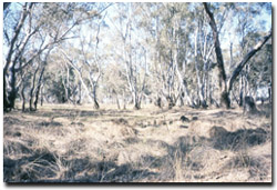 Woodstock Reserve in spring 2002 |
Tree Health
Eight are monitored for tree canopy health using a 20-point system assessing canopy size and density, number of dead branches and extent of epicormic growth. Leaf damage by insects is also assessed. Tree health is generally quite high at the site with most trees recording an improvement in health since monitoring began in 1997. Most trees were too tall for leaf analysis, however the one Red Gum that could be reached had significant amounts of leaf insect damage exacerbated by drought stress.
Groundwater and Salinity
Two bores are located near the site and have remained dry since 1997. Therefore that water table must be at least 17 metres below natural surface. Although the regional water table is very deep, the drainage line running through the reserve could possibly be a source of saline discharge although there has never been evidence to suggest that this has occurred.
Birds
Bird species seen at the time of vegetation and tree health surveys include:-
Australian Raven, Black-faced Cuckoo-shrike, Galah, Grey Butcherbird, Kookaburra, Magpie, Noisy Miner, Red Wattlebird, Striated Pardalote, Weebill, Corella, Superb Fairy Wren, Eastern Rosella, Rufous Whistler, and Little Raven.
Site Threats
- weed invasion but in particular, previously recorded on site,
- Genista monspessulana Cape Broom and Oxalis pes-caprae Soursob.
- Possible grazing.
- road drainage is now directed across the site.
© State of Victoria (Agriculture Victoria) 1996 - 2025.

This work, Victorian Resources Online, is licensed under a Creative Commons Attribution 4.0 licence. You are free to re-use the work under that licence, on the condition that you credit the State of Victoria (Agriculture Victoria) as author, indicate if changes were made and comply with the other licence terms.
The licence does not apply to ‘branding’ or some ‘images or photographs’ that may be owned by third parties. We ask you to seek prior approval to use images using the VRO feedback form. Access to higher quality images can also be provided on request.
This page was last updated on 23/03/2020.