
Site 13 Jennings Bushland Reserve
This site appears to be in an environmentally stable condition at present but could decline if weed species continue to increase in cover abundance.
Description
This site is located at the break of slope on the northern side of the Black Range and could be at future risk from dryland salinity. Groundwater discharge has been mapped 1km west from the reserve. The land units are comprised of northern granites and metamorphic ridges and the site is at an elevation of 235 metres. The Reserve did have a bee farm and range licence in the past and the Central Goldfields shire have used the area to store gravel for road works. Parks Victoria now manages the reserve as a conservation area.
| Vegetation Description and Composition The site contains Box Ironbark forest EVC, listed as depleted in the Goldfields Bioregion. The remnant vegetation community is relatively intact and a good representation of the original vegetation for the area, although the tree densities have been modified by previous clearing activities. The site is dominated by Eucalyptus leucoxylon (Yellow Gum) and Eucalyptus microcarpa (Grey Box) with a shrub layer of Dillwynia cinerascens (Grey Parrot-pea), Pultenaea largiflorens (Twiggy Bush-pea) and Acacia acinacea (Gold-dust Wattle). The Herbaceous layer consists of Danthonia spp. (Wallaby Grass) and Lomandra spp. (Mat Rush). The most significant introduced species in this almost intact vegetation community continues to be Briza maxima (Quaking Grass) and the recent appearance of Lolium spp. (Rye Grass) and Avena fatua (Wild Oats). | 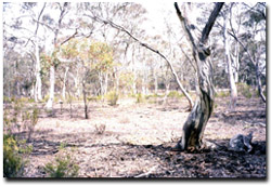 Jennings Bushland Reserve, the dominant shrub is Cassinia arcuata that indicates that the site has experienced previous soil disturbance. |
There were no salt indicator species present in 1997 or 1998. The recent appearance of Lolium spp. (Rye Grass) may indicate a salt problem, but is a common agricultural weed and is most likely present due to dry seasonal conditions and from the effects of surrounding agricultural land use.
There had been an increase each year in the percentage of introduced species of approximately 50%, however over the last three years there has been minimal change.
Tree Health
Eight trees are monitored for tree canopy health using a 20-point system assessing canopy size and density, number of dead branches and extent of epicormic growth. Leaf damage by insects is also assessed. Most trees have experienced declining health since 1997 due to reduced canopy size and densities. The trees will hopefully improve in condition once adequate rainfall is received in the area. However, canopy health is also lower at this site than others due to the high density of trees per hectare, induced by previous clearing activities and subsequent coppice regrowth.
Groundwater and Salinity
The one bore has recorded a drop in the water table in response to dry seasonal conditions and was 13.2 metres below natural surface in 2002. The salinity reading of the groundwater was >12 000 EC (i.e. extremely saline water).
Birds
Bird species present at the time of the vegetation and tree health surveys were :-
Brown Treecreeper, Magpie, Rainbow Bee-eater, Red-rumped Parrot, Red Wattlebird Welcome Swallow, White-plumed Honeyeater, White-browed Woodswallow, Willie Wagtail, White winged Chough, Eastern Rosella and Striated Pardalote.
Site Threats
- weed invasion.
- disturbance through gully erosion and surface scouring.
- rabbit, hare and kangaroo grazing pressures have still continued to increase.
© State of Victoria (Agriculture Victoria) 1996 - 2025.

This work, Victorian Resources Online, is licensed under a Creative Commons Attribution 4.0 licence. You are free to re-use the work under that licence, on the condition that you credit the State of Victoria (Agriculture Victoria) as author, indicate if changes were made and comply with the other licence terms.
The licence does not apply to ‘branding’ or some ‘images or photographs’ that may be owned by third parties. We ask you to seek prior approval to use images using the VRO feedback form. Access to higher quality images can also be provided on request.
This page was last updated on 23/03/2020.