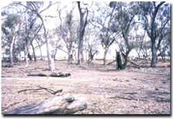
Site 10 Repper Swamp
Site is of uncertain environmental stability
Description
The area is freehold and currently grazed with cropping adjacent to the sites.
The site is on a drainage line 500 m west of the Avoca River at an altitude of 100 m and is part of an alluvial plain sloping slightly to the northeast.
The area has high habitat value due to extensive Open Woodland dominated by a range of sizes of Eucalyptus largiflorens (Black Box) and Eucalyptus camaldulensis (Red Gum) and the proximity of the Avoca River.
Vegetation Description and Composition This ephemeral wetland is Plains Grassy Wetland EVC, dominated by large Eucalyptus largiflorens (Black Box) and large Eucalyptus camaldulensis (Red Gum). The understorey consists of predominantly members of the Cyperaceae (Sedge) and Juncaceae (Rush) families. In both quadrats the total number of plant species present has been reduced by 25%. Also the level of abundance has decreased and the amount of leaf litter has increased since monitoring commenced in 1997. All of these changes can be attributed to the continued dry conditions. There are now four salt indicator species present being Critesion marinum (Sea barley grass), Chloris truncata (Windmill grass), Atriplex semibaccata (Berry saltbush) and Lolium spp. (Rye Grass). Only Sea barley grass and Rye grass were recorded in 1997. It is unlikely that salinity is the reason for the increase in salt indicator species, for Windmill grass and Berry Saltbush are commonly found in arid environments and may now be present due to continued dry conditions and from the decrease in competition from introduced species. The only way to know for certain is to perform soil salinity tests. |  Fallen timber increases the habitat value of the site |
Tree Health
Eight trees are monitored for tree canopy health using a 20-point system assessing canopy size and density, number of dead branches and extent of epicormic growth. Leaf damage by insects is also assessed. The six Black Box trees have remained stable or recorded an increase in health since 1997. The two Red Gum trees however have suffered serious tree decline health since 1997, most likely due to the prolonged period without inundation. They cannot withstand long periods of drought like Black Box trees can. These trees contain many dead branches, extensive epicormic growth and severe leaf damage by lerps and leaf skeletoniser caterpillars, indicating severe drought stress.
Groundwater and salinity
The one bore in the area 400 m north of the Avoca river was dry in spring 2002, therefore the water table is at least 17 m below natural surface.
Birds
Bird species present at the time of the vegetation and tree health surveys were :-
Galah, Kookaburra, Magpie, Red-rumped Parrot, Sulphur-crested Cockatoo, Welcome Swallow, White-plumed Honeyeater, Willie Wagtail, Eastern Rosella, Corella, Australian Raven, Noisy Miner, Striated Pardalote, Black Faced Cuckoo Shrike and an unidentified Raptor species.
Threats to the site continue to be:
- stock grazing (site still needs to be fenced)
- weed invasion
- long term groundwater and salinity levels are unknown
- poor health of aging trees and no regeneration


