
Groundwater Flow Systems
Back to Bet Bet Creek Catchment Homepage
Groundwater Flow Systems (GFS) were developed as part of the former National Land and Water Resources Audit as a framework for dryland salinity management in Australia. Originally developed in a broad national context, GFSs have since been applied at the Murray Darling Basin scale and consequently Catchment Management Authority scale to support and underpin the development of salinity management strategies across regional jurisdictions.
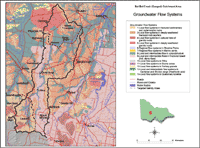 Bet Bet Groundwater Flow Systems | This map has been developed using the GFS250 dataset - which joins the mapping for the Victorian CMAs, where a GFS framework has been developed, and presents a statewide map with a consistent attribute set. More detailed maps for the Bet Bet and Timor West targeted salinity areas can be accessed by clicking onto those areas from this map. These more detailed maps also show mapped salinity discharge areas as well as current bore site locations. The GFS framework encompasses: (a) identification of generalised conceptual models of groundwater behaviour in each of the region’s geological and geomorphic provinces, (b) an assessment of the physical attributes of each system, and (c) first order consideration of potential salinity management strategies applicable within each GFS. A GFS will exhibit similar physical characteristics across its extent, and generally incorporate the complete groundwater flow path from recharge to discharge. Central to the framework is the assessment of the hydrogeological responsiveness of a GFS that guides appropriate land use to assist in the management of salinity. |
The development GFS framework for a region is typically undertaken through intense workshopping involving local expertise, then this documented in a regional GFS map and accompanying report. | |
© State of Victoria (Agriculture Victoria) 1996 - 2025.

This work, Victorian Resources Online, is licensed under a Creative Commons Attribution 4.0 licence. You are free to re-use the work under that licence, on the condition that you credit the State of Victoria (Agriculture Victoria) as author, indicate if changes were made and comply with the other licence terms.
The licence does not apply to ‘branding’ or some ‘images or photographs’ that may be owned by third parties. We ask you to seek prior approval to use images using the VRO feedback form. Access to higher quality images can also be provided on request.
This page was last updated on 23/03/2020.